IMAGES TAKEN NEAR TO
Sarum Road, WINCHESTER, SO22 5EZ
Introduction
This page details the photographs taken nearby to Sarum Road, SO22 5EZ by members of the Geograph project.
The Geograph project started in 2005 with the aim of publishing, organising and preserving representative images for every square kilometre of Great Britain, Ireland and the Isle of Man.

There are currently over 7.5m images from over14,400 individuals and you can help contribute to the project by visiting https://www.geograph.org.uk
Image Map
Images are licensed for reuse under creativecommons.org/licenses/by-sa/2.0
Notes
- Clicking on the map will re-center to the selected point.
- The higher the marker number, the further away the image location is from the centre of the postcode.
Image Listing (44 Images Found)
Images are licensed for reuse under creativecommons.org/licenses/by-sa/2.0
Image
Details
Distance
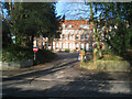
8
Winchester - King Alfred's University
Established on this site in 1862 as King Alfred's College as a training school for teachers, In the following years many changes occurred including admitting women in 1960, King Alfred's finally became a University in 2005.
Image: © Chris Talbot
Taken: 28 Sep 2011
0.12 miles
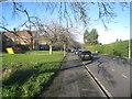
10
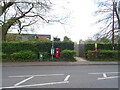
Bus stop on Romsey Road, Winchester
Showing position of Postbox No. SO22 47.
See Image] for postbox.
Image: © JThomas
Taken: 25 Apr 2022
0.13 miles