IMAGES TAKEN NEAR TO
Ivy Close, WINCHESTER, SO22 4QR
Introduction
This page details the photographs taken nearby to Ivy Close, SO22 4QR by members of the Geograph project.
The Geograph project started in 2005 with the aim of publishing, organising and preserving representative images for every square kilometre of Great Britain, Ireland and the Isle of Man.

There are currently over 7.5m images from over14,400 individuals and you can help contribute to the project by visiting https://www.geograph.org.uk
Image Map (Loading...)


Getting Data...Please wait
Leaflet Map data © OpenStreetMap
Images are licensed for reuse under creativecommons.org/licenses/by-sa/2.0
Notes
- Clicking on the map will re-center to the selected point.
- The higher the marker number, the further away the image location is from the centre of the postcode.
Image Listing (54 Images Found)
Images are licensed for reuse under creativecommons.org/licenses/by-sa/2.0
Image
Details
Distance
1
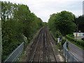
Railway from the Clarendon Way
Looking north from the footbridge that carries the Clarendon Way over the London/Southampton line.
Image: © Chris Heaton
Taken: 10 May 2010
0.05 miles
2
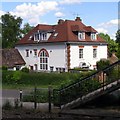
St. Nicholas, Mead Road, St Cross
This white house is called "St Nicholas" and is at the top of Mead Road where it meets Whiteshute Lane. This view is from the steps of the footbridge across the railway line - the steps on the far side can be seen in the foreground.
Image: © Jim Champion
Taken: 29 May 2007
0.06 miles
3
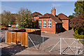
Stanmore Primary School
[Elevated camera position]
Image: © Peter Facey
Taken: 22 Sep 2012
0.07 miles
4
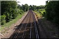
Railway line to Southampton, St Cross
Looking along the tracks of the mainline to Southampton from the footbridge at the top of Mead Road. Before the railway line was here Whiteshute Lane extended from the Roman Road to Winchester up Whiteshute Ridge. Now it is broken by the railway tracks, with the upper portion of the lane as a bridleway. The Clarendon Way footpath from Salisbury Cathedral to Winchester Cathedral crosses the tracks via this footbridge too.
Image: © Jim Champion
Taken: 29 May 2007
0.08 miles
5

Footbridge carrying the Clarendon Way
The Way crossing the main London-Winchester-Southampton railway line.
Image: © Tim Heaton
Taken: 10 May 2010
0.09 miles
6
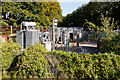
33/11KV Electricity Substation, Stanmore Lane
This substation takes power at 33KV from Image, via overhead lines seen in Image It delivers power to Stanmore and the nearby railway line.
[elevated camera position]
Image: © Peter Facey
Taken: 22 Sep 2012
0.09 miles
7
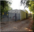
St Cross electricity substation, Winchester
Set back from the south side of Stanmore Lane, near this http://www.geograph.org.uk/photo/4186466 railway bridge.
Image: © Jaggery
Taken: 28 Sep 2014
0.10 miles
8
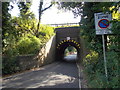
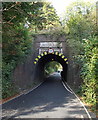
Stanmore Lane railway bridge, Winchester
Headroom is shown as 10' 6" between the two vertical lines on the bridge.
The road is Stanmore Lane on this side, Lower Stanmore Lane on the far side of the bridge.
Image: © Jaggery
Taken: 28 Sep 2014
0.13 miles
10
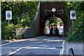
Lower Stanmore Lane railway bridge, Winchester
Headroom is shown as 10' 6" between the two vertical lines on the bridge.
Above it, a faded notice shows CAUTION SCHOOL.
The road is Lower Stanmore Lane on this side, Stanmore Lane on the far side of the bridge.
Image: © Jaggery
Taken: 28 Sep 2014
0.13 miles