IMAGES TAKEN NEAR TO
Plough Way, WINCHESTER, SO22 4PW
Introduction
This page details the photographs taken nearby to Plough Way, SO22 4PW by members of the Geograph project.
The Geograph project started in 2005 with the aim of publishing, organising and preserving representative images for every square kilometre of Great Britain, Ireland and the Isle of Man.

There are currently over 7.5m images from over14,400 individuals and you can help contribute to the project by visiting https://www.geograph.org.uk
Image Map (Loading...)


Getting Data...Please wait
Leaflet Map data © OpenStreetMap
Images are licensed for reuse under creativecommons.org/licenses/by-sa/2.0
Notes
- Clicking on the map will re-center to the selected point.
- The higher the marker number, the further away the image location is from the centre of the postcode.
Image Listing (10 Images Found)
Images are licensed for reuse under creativecommons.org/licenses/by-sa/2.0
Image
Details
Distance
1
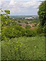
View towards Winchester from Whiteshute Ridge
Whiteshute Ridge is an area of "traditional downland" to the southeast of Badger Farm (the housing estate seen in the middle distance). In the far distance Winchester Cathedral is an obvious landmark.
Image: © Jim Champion
Taken: 29 May 2007
0.02 miles
2

Seat with a view from Whiteshute Ridge
A slate toposcope is on the left. Housing in the suburb of Badger Farm, developed in the 70s and 80s, is visible below the ridge in the middle distance
Image: © Tim Heaton
Taken: 10 May 2010
0.10 miles
3
St Catherine's Hill from near Whiteshute Lane
The tower of St Cross Hospital peeking above the trees.
From the Clarendon Way.
Image: © James Hardiman
Taken: 31 Aug 2009
0.13 miles
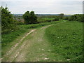
4
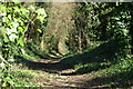
Whiteshute Lane
A sunken trackway which heads southwest from St Cross along the chalk Whiteshute Ridge towards Hursley.
Image: © Pierre Terre
Taken: 6 Apr 2006
0.13 miles
5
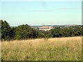
Winchester Cathedral from Whiteshute Hill
The Clarendon Way follows an ancient sunken track just behind the photographer - Whiteshute Lane. But the views are better from the track on the hillside that parallels the lane.
Part of a series of pictures that illustrates a walk in my Inheritance Walks. www.tinyurl.com/clarendonone
Previous: Image
Next: Image
Image: © James Hardiman
Taken: 31 Aug 2009
0.13 miles
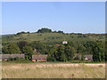
6
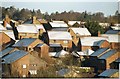
Badger Farm Roofscape
Badger Farm from Whiteshute Ridge
Image: © Pierre Terre
Taken: 29 Jan 2004
0.17 miles
7
Whiteshute Ridge
One of Hampshire's few remaining tracts of chalk down - according to a slightly worn notice.
Image: © Chris Heaton
Taken: 10 May 2010
0.19 miles
8
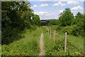
Path parallel to Whiteshute Lane
Whiteshute Lane runs parallel to this path, on the other side of the trees to the left of this photo. The general public is permitted to use the field to the right for recreation (on foot) and has recently been fenced in so that it can be grazed by cattle.
Image: © Jim Champion
Taken: 29 May 2007
0.20 miles
9
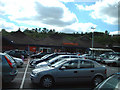
Sainsbury's supermarket, Badger Farm, Winchester
Sainsbury's "out-of-town" store in Winchester is hidden in what must have been an old quarry, with lots of trees around the edge.
Image: © Peter Jordan
Taken: 28 Aug 2005
0.21 miles
10
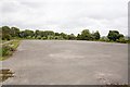
Parade Ground at Bushfield Camp
At least I presume that is what it was. Bushfield Camp was an army training camp functioning during WWII and also used to train recruits to the Royal Green Jackets regiment between 1961-64. The internet is strangely silent about its history. It is totally derelict today. The area is the subject of an ongoing debate as to its future use.
Image: © Peter Facey
Taken: 1 Sep 2008
0.24 miles