IMAGES TAKEN NEAR TO
Lake Drive, WINCHESTER, SO22 4PB
Introduction
This page details the photographs taken nearby to Lake Drive, SO22 4PB by members of the Geograph project.
The Geograph project started in 2005 with the aim of publishing, organising and preserving representative images for every square kilometre of Great Britain, Ireland and the Isle of Man.

There are currently over 7.5m images from over14,400 individuals and you can help contribute to the project by visiting https://www.geograph.org.uk
Image Map
Images are licensed for reuse under creativecommons.org/licenses/by-sa/2.0
Notes
- Clicking on the map will re-center to the selected point.
- The higher the marker number, the further away the image location is from the centre of the postcode.
Image Listing (3 Images Found)
Images are licensed for reuse under creativecommons.org/licenses/by-sa/2.0
Image
Details
Distance
1
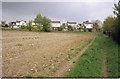
Edge of town
Houses in Prior's Way, Oliver's Battery, backing on to open farmland (so far).
Image: © Pierre Terre
Taken: 15 Apr 2005
0.01 miles
2
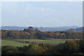
View to Portsdown Hill
In the right conditions the installations on Portsdown Hill can be seen from the footpath south of Oliver's Battery. These include the towers at the Naval Research Establishment Image (the left-most white obelisk) and (I think) Fort Nelson.
Image: © Pierre Terre
Taken: 9 Nov 2005
0.01 miles
3
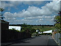
View north west from Oliver's Battery, Winchester
View north west from Old Kennels Lane, Oliver's Battery, Winchester. 1960s houses and in the background, South Winchester golf course which covers the western third of the grid square.
Image: © Peter Jordan
Taken: 28 Aug 2005
0.10 miles