IMAGES TAKEN NEAR TO
St. Annes Close, WINCHESTER, SO22 4LQ
Introduction
This page details the photographs taken nearby to St. Annes Close, SO22 4LQ by members of the Geograph project.
The Geograph project started in 2005 with the aim of publishing, organising and preserving representative images for every square kilometre of Great Britain, Ireland and the Isle of Man.

There are currently over 7.5m images from over14,400 individuals and you can help contribute to the project by visiting https://www.geograph.org.uk
Image Map
Images are licensed for reuse under creativecommons.org/licenses/by-sa/2.0
Notes
- Clicking on the map will re-center to the selected point.
- The higher the marker number, the further away the image location is from the centre of the postcode.
Image Listing (3 Images Found)
Images are licensed for reuse under creativecommons.org/licenses/by-sa/2.0
Image
Details
Distance
1
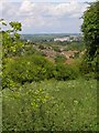
View towards Winchester from Whiteshute Ridge
Whiteshute Ridge is an area of "traditional downland" to the southeast of Badger Farm (the housing estate seen in the middle distance). In the far distance Winchester Cathedral is an obvious landmark.
Image: © Jim Champion
Taken: 29 May 2007
0.19 miles
3
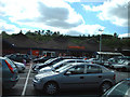
Sainsbury's supermarket, Badger Farm, Winchester
Sainsbury's "out-of-town" store in Winchester is hidden in what must have been an old quarry, with lots of trees around the edge.
Image: © Peter Jordan
Taken: 28 Aug 2005
0.24 miles