IMAGES TAKEN NEAR TO
Old Kennels Close, WINCHESTER, SO22 4LB
Introduction
This page details the photographs taken nearby to Old Kennels Close, SO22 4LB by members of the Geograph project.
The Geograph project started in 2005 with the aim of publishing, organising and preserving representative images for every square kilometre of Great Britain, Ireland and the Isle of Man.

There are currently over 7.5m images from over14,400 individuals and you can help contribute to the project by visiting https://www.geograph.org.uk
Image Map
Images are licensed for reuse under creativecommons.org/licenses/by-sa/2.0
Notes
- Clicking on the map will re-center to the selected point.
- The higher the marker number, the further away the image location is from the centre of the postcode.
Image Listing (5 Images Found)
Images are licensed for reuse under creativecommons.org/licenses/by-sa/2.0
Image
Details
Distance
1
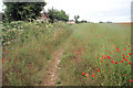
Footpath behind Old Kennels Lane
An informal path around the corner of a large field.
Image: © Pierre Terre
Taken: 5 Jul 2008
0.15 miles
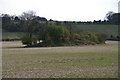
2
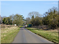
Port Lane approaching Oliver's Battery
Image: © Robin Webster
Taken: 13 Feb 2017
0.17 miles
3
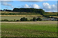
Fields below Millers Lane with Yew Hill in the distance
There is a substantial electrical substation on Port Lane to the right of the image.
Image: © David Martin
Taken: 23 Aug 2015
0.22 miles
4
Pigs might fly
A surreal view of pig arks on the hill above Port Lane (Miller's lane on the right), taken from the bridleway to the north of Yew Hill reservoir
Image: © Pierre Terre
Taken: 9 Nov 2005
0.23 miles
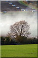
5
Tumulus near 'Texas', Oliver's Battery
A large Bronze Age round barrow.
Image: © Pierre Terre
Taken: 6 Apr 2008
0.24 miles