IMAGES TAKEN NEAR TO
New Queens Gate, WINCHESTER, SO22 4FG
Introduction
This page details the photographs taken nearby to New Queens Gate, SO22 4FG by members of the Geograph project.
The Geograph project started in 2005 with the aim of publishing, organising and preserving representative images for every square kilometre of Great Britain, Ireland and the Isle of Man.

There are currently over 7.5m images from over14,400 individuals and you can help contribute to the project by visiting https://www.geograph.org.uk
Image Map
Images are licensed for reuse under creativecommons.org/licenses/by-sa/2.0
Notes
- Clicking on the map will re-center to the selected point.
- The higher the marker number, the further away the image location is from the centre of the postcode.
Image Listing (57 Images Found)
Images are licensed for reuse under creativecommons.org/licenses/by-sa/2.0
Image
Details
Distance
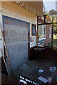
1
The New Queens Head bricked up
At time of photographing the pub was closed and all its external doors and windows were bricked up. Earlier http://www.geograph.org.uk/photo/864964
Image: © Peter Facey
Taken: 22 Sep 2012
0.00 miles
2
The New Queens Head bricked up
All external doors and windows of this pub had been sealed with high density concrete blockwork - a thorough job. Earlier http://www.geograph.org.uk/photo/864964
Image: © Peter Facey
Taken: 22 Sep 2012
0.00 miles
3
The New Queens Head bricked up
All external doors and windows had been well sealed with high density concrete blockwork. Earlier http://www.geograph.org.uk/photo/864964
Image: © Peter Facey
Taken: 22 Sep 2012
0.00 miles
4
Bricked up vestibule of New Queens Head pub
All external doors and windows of this pub had been sealed with high density concrete blocks. Earlier http://www.geograph.org.uk/photo/864964
Image: © Peter Facey
Taken: 22 Sep 2012
0.01 miles
5
The New Queens Head bricked up
All external doors and windows had been bricked up. Earlier http://www.geograph.org.uk/photo/864964
Image: © Peter Facey
Taken: 22 Sep 2012
0.01 miles
8
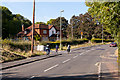
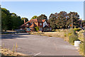
Fenced-off side of Stanmore Lane, Winchester
A long white fence extends along the south side of Stanmore Lane.
Peeping above the fence in the middle distance, a pub sign shows NEW QUEENS HEAD.
Image: © Jaggery
Taken: 28 Sep 2014
0.01 miles
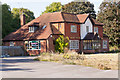
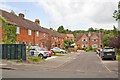
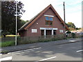
9
Front of Winchester Family Church, Stanmore Lane
See also Image
Image: © Peter Facey
Taken: 29 Jun 2008
0.03 miles
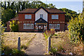
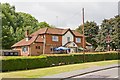
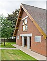
10
Level 10 Church, Stanmore, Winchester
The church building extends for 40 metres back from the south side of Stanmore Lane, opposite the Cromwell Road junction. The Christian church's name is a reference to a verse in the Bible, John 10:10
"I have come that you may have life and life in all abundance, to the full and overflowing".
Image: © Jaggery
Taken: 28 Sep 2014
0.03 miles