IMAGES TAKEN NEAR TO
Walpole Road, WINCHESTER, SO22 4ES
Introduction
This page details the photographs taken nearby to Walpole Road, SO22 4ES by members of the Geograph project.
The Geograph project started in 2005 with the aim of publishing, organising and preserving representative images for every square kilometre of Great Britain, Ireland and the Isle of Man.

There are currently over 7.5m images from over14,400 individuals and you can help contribute to the project by visiting https://www.geograph.org.uk
Image Map (Loading...)


Getting Data...Please wait
Leaflet Map data © OpenStreetMap
Images are licensed for reuse under creativecommons.org/licenses/by-sa/2.0
Notes
- Clicking on the map will re-center to the selected point.
- The higher the marker number, the further away the image location is from the centre of the postcode.
Image Listing (23 Images Found)
Images are licensed for reuse under creativecommons.org/licenses/by-sa/2.0
Image
Details
Distance
2

Underpass, Oliver's Battery, Winchester
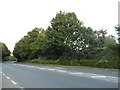
A colourful section of the Clarendon Way beneath the A3090
Image: © Tim Heaton
Taken: 10 May 2010
0.10 miles
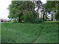
3
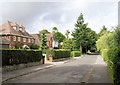
Oliver's Battery Road North
Once the only road from Winchester to Oliver's Battery and originally a rough chalk track, Oliver's Battery Road North is today cut off to the south by Badger Farm Road.
Image: © Pierre Terre
Taken: 19 Aug 2008
0.14 miles
4
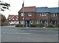
New houses on Winchester Village Development
Image: © David Howard
Taken: 3 Jul 2017
0.14 miles
5
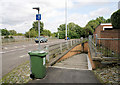
Badger Farm Road
Badger Farm Road bisected Oliver's Battery in the late 1960s and is now one of Winchester's main links to the M3. This pedestrian subway links the two halves of Oliver's Battery Road today.
Image: © Pierre Terre
Taken: 19 Aug 2008
0.15 miles
6
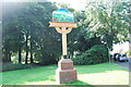
Village sign for Oliver's Battery
This sign is located at the junction of Oliver's Battery Road South with Downlands Road. https://en.wikipedia.org/wiki/Olivers_Battery
Image: © Barry Shimmon
Taken: 10 Aug 2012
0.15 miles
7
Oliver's Battery earthworks, Winchester
Probably an Iron Age earthwork. Local custom holds that the site was used by Oliver Cromwell's cannon during the siege of 1645.
Image: © Tim Heaton
Taken: 10 May 2010
0.16 miles
8
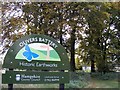
Oliver's Battery Historic Earthworks Sign
St Mark's Church is in the background.
Image: © David Spender
Taken: 23 Oct 2008
0.16 miles
9
Church of St Stephen, Winchester
Viewed from the Clarendon Way on Oliver's Battery Road North
Image: © Tim Heaton
Taken: 10 May 2010
0.17 miles
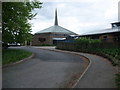
10
Olivers Battery, St. Stephen's Catholic Church
On Olivers Battery Road North: http://www.hampshiredowns.org.uk/StStephenWinchester.aspx
Image: © Mike Faherty
Taken: 4 Aug 2013
0.17 miles