IMAGES TAKEN NEAR TO
Mount View Close, WINCHESTER, SO22 4BQ
Introduction
This page details the photographs taken nearby to Mount View Close, SO22 4BQ by members of the Geograph project.
The Geograph project started in 2005 with the aim of publishing, organising and preserving representative images for every square kilometre of Great Britain, Ireland and the Isle of Man.

There are currently over 7.5m images from over14,400 individuals and you can help contribute to the project by visiting https://www.geograph.org.uk
Image Map
Images are licensed for reuse under creativecommons.org/licenses/by-sa/2.0
Notes
- Clicking on the map will re-center to the selected point.
- The higher the marker number, the further away the image location is from the centre of the postcode.
Image Listing (21 Images Found)
Images are licensed for reuse under creativecommons.org/licenses/by-sa/2.0
Image
Details
Distance
1
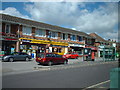
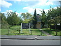
Oliver's Battery village shops
Oliver's Battery is a village south west of Winchester. It adjoins the city, so it's really a suburb. The quaint name derives from the prehistoric earth work which was used as a camp by Oliver Cromwell during the Civil War. Today, there is mainly 1960s residential development and the shops seem to be the heart of the place.
Image: © Peter Jordan
Taken: 28 Aug 2005
0.12 miles
3
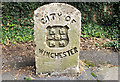
Boundary Stone
A cast concrete boundary marker in Oliver's Battery Road South. I think this marks a corner of the former Municipal Borough boundary - the modern City of Winchester district extends far beyond.
Image: © Pierre Terre
Taken: 19 Aug 2008
0.13 miles
4
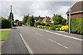
Compton Way
This suburban street in Oliver's Battery is also part of the route of the Clarendon Way footpath from Winchester to Salisbury. It has views across the Itchen Valley to St Catherine's Hill.
Image: © Pierre Terre
Taken: 19 Aug 2008
0.13 miles
5
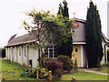
St Mark's Church, Oliver's Battery
Adjacent to the local shops, on Oliver's Battery Road. Judging from its appearance, I would guess it predates most of the residential development
Image: © Peter Jordan
Taken: 28 Aug 2005
0.14 miles
6
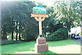
Village sign for Oliver's Battery
This sign is located at the junction of Oliver's Battery Road South with Downlands Road. https://en.wikipedia.org/wiki/Olivers_Battery
Image: © Barry Shimmon
Taken: 10 Aug 2012
0.15 miles
8
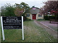
Church of St Mark, Oliver's Battery, Winchester
Image: © Tim Heaton
Taken: 10 May 2010
0.15 miles
9
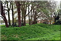
Earthworks, Oliver's Battery
Though long known as Oliver Cromwell's Battery, the earthworks here are actually probably Roman, on an Iron Age site. The shops Image and church Imagecan be seen through the trees.
Image: © Pierre Terre
Taken: 26 Apr 2006
0.16 miles
10
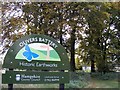
Oliver's Battery Historic Earthworks Sign
St Mark's Church is in the background.
Image: © David Spender
Taken: 23 Oct 2008
0.16 miles