IMAGES TAKEN NEAR TO
Sutton Scotney, WINCHESTER, SO21 3NU
Introduction
This page details the photographs taken nearby to SO21 3NU by members of the Geograph project.
The Geograph project started in 2005 with the aim of publishing, organising and preserving representative images for every square kilometre of Great Britain, Ireland and the Isle of Man.

There are currently over 7.5m images from over14,400 individuals and you can help contribute to the project by visiting https://www.geograph.org.uk
Image Map
Images are licensed for reuse under creativecommons.org/licenses/by-sa/2.0
Notes
- Clicking on the map will re-center to the selected point.
- The higher the marker number, the further away the image location is from the centre of the postcode.
Image Listing (3 Images Found)
Images are licensed for reuse under creativecommons.org/licenses/by-sa/2.0
Image
Details
Distance
1
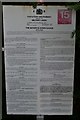
Byelaws for the Moody's Down Range
An intriguing set of byelaws posted at the corner of the military firing range. Primarily defining the area of the range and prohibiting unauthorised access, digging for projectiles or theft of War department stores. Fine for infringement not exceeding FIVE pounds. If you'd like a copy of the byelaws they are one shilling for each copy...
Image: © David Martin
Taken: 31 Aug 2018
0.05 miles