IMAGES TAKEN NEAR TO
Gratton Close, WINCHESTER, SO21 3LG
Introduction
This page details the photographs taken nearby to Gratton Close, SO21 3LG by members of the Geograph project.
The Geograph project started in 2005 with the aim of publishing, organising and preserving representative images for every square kilometre of Great Britain, Ireland and the Isle of Man.

There are currently over 7.5m images from over14,400 individuals and you can help contribute to the project by visiting https://www.geograph.org.uk
Image Map
Images are licensed for reuse under creativecommons.org/licenses/by-sa/2.0
Notes
- Clicking on the map will re-center to the selected point.
- The higher the marker number, the further away the image location is from the centre of the postcode.
Image Listing (48 Images Found)
Images are licensed for reuse under creativecommons.org/licenses/by-sa/2.0
Image
Details
Distance
1
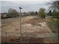
Sutton Scotney railway station (site), Hampshire, 2017
Opened in 1885 by the Didcot Newbury & Southampton Railway, later part of the Great Western Railway, on the line from Newbury to Winchester (Chesil), this station closed to passengers in 1960.
View north towards Barton Stacey and Newbury. The site had recently been cleared ready for a new housing development.
Image: © Nigel Thompson
Taken: 23 Mar 2017
0.09 miles
2
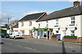
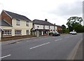
Dever Stores, Sutton Scotney
Named after the River Dever that passes through the village. This road used to be the main A34 and as it crossed the A30 just north of here there was always a traffic bottleneck in Sutton Scotney. Now it has all been bypassed and the village is quieter. The only bottleneck today was someone parking inconsiderately on the left (shadow just seen) at the narrowest part of the road to pop into the stores.
Image: © Graham Horn
Taken: 7 Apr 2011
0.13 miles
3
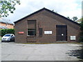
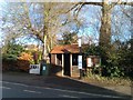
Telephone Exchange, Sutton Scotney
Situated in Oxford Road, this modern redbrick TE serves Sutton Scotney, plus Barton Stacey, Lower Bullington, Stoke Charity, Upper Bullington and Wonston nearby. Besides the BT warning notices, this TE also has a red notice which says "This area has been designated for the use only by Royal Mail. For parking up to three vehicles". The numbering range for this TE is (01962) 76xxxx, the (01962) referring to the Winchester group of TEs. Its postcode is SO21 3JG.
Image: © David Hillas
Taken: 8 Jul 2011
0.14 miles
4
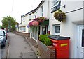
Convenience Store, Sutton Scotney
The local store with Post Office is still operating in the village.
Image: © mike smith
Taken: 5 Aug 2013
0.15 miles
5
Sutton Scotney, Dever Stores
Village stores on Oxford Road: http://www.deverstores.co.uk/
Image: © Mike Faherty
Taken: 1 Jul 2013
0.15 miles
7

Sutton Scotney
Looking north up Oxford Road to its junction with the A30.
Image: © Penny Mayes
Taken: 13 Sep 2005
0.16 miles
8
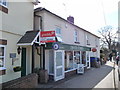
Sutton Scotney - Post Office
Sutton Scotney Post Office and village store.
Image: © Chris Talbot
Taken: 14 Mar 2010
0.16 miles
9
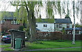
Houses in Sutton Scotney
This is the former A34, and the village was always a major traffic bottleneck. Nowadays these houses by the bus stop are on a much quieter road.
Image: © Graham Horn
Taken: 7 Apr 2011
0.16 miles
10
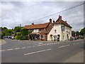
Sutton Scotney, The Coach & Horses
Village pub with accommodation on Oxford Road. Internally, back bar, with drinking and eating rooms front, left and right; small public bar with darts, games machine; beams, fireplace and some exposed brickwork and wooden panelling; garden. Cask ales on offer at my visit: Black Sheep Golden Sheep, Bowman Swift One, Goddards Fuggle-dee-dum. For some customer comments, see http://www.beerintheevening.com/pubs/s/22/22529/Coach_and_Horses/Sutton_Scotney
Image: © Mike Faherty
Taken: 1 Jul 2013
0.17 miles