IMAGES TAKEN NEAR TO
Oxford Road, WINCHESTER, SO21 3JH
Introduction
This page details the photographs taken nearby to Oxford Road, SO21 3JH by members of the Geograph project.
The Geograph project started in 2005 with the aim of publishing, organising and preserving representative images for every square kilometre of Great Britain, Ireland and the Isle of Man.

There are currently over 7.5m images from over14,400 individuals and you can help contribute to the project by visiting https://www.geograph.org.uk
Image Map
Images are licensed for reuse under creativecommons.org/licenses/by-sa/2.0
Notes
- Clicking on the map will re-center to the selected point.
- The higher the marker number, the further away the image location is from the centre of the postcode.
Image Listing (53 Images Found)
Images are licensed for reuse under creativecommons.org/licenses/by-sa/2.0
Image
Details
Distance
1
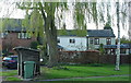
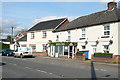
Houses in Sutton Scotney
This is the former A34, and the village was always a major traffic bottleneck. Nowadays these houses by the bus stop are on a much quieter road.
Image: © Graham Horn
Taken: 7 Apr 2011
0.01 miles
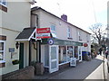
2
Sutton Scotney, Dever Stores
Village stores on Oxford Road: http://www.deverstores.co.uk/
Image: © Mike Faherty
Taken: 1 Jul 2013
0.03 miles
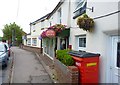
3
Sutton Scotney - Post Office
Sutton Scotney Post Office and village store.
Image: © Chris Talbot
Taken: 14 Mar 2010
0.03 miles
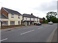
4

Sutton Scotney
Looking north up Oxford Road to its junction with the A30.
Image: © Penny Mayes
Taken: 13 Sep 2005
0.03 miles
5
Convenience Store, Sutton Scotney
The local store with Post Office is still operating in the village.
Image: © mike smith
Taken: 5 Aug 2013
0.04 miles
6
Dever Stores, Sutton Scotney
Named after the River Dever that passes through the village. This road used to be the main A34 and as it crossed the A30 just north of here there was always a traffic bottleneck in Sutton Scotney. Now it has all been bypassed and the village is quieter. The only bottleneck today was someone parking inconsiderately on the left (shadow just seen) at the narrowest part of the road to pop into the stores.
Image: © Graham Horn
Taken: 7 Apr 2011
0.04 miles
8
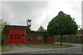
Sutton Scotney Fire Station
Sutton Scotney Fire Station, Oxford Road, Sutton Scotney, Hampshire, lies adjacent to the Old Fire Station Image in the car park of the Coach & Horses Inn
Image: © Kevin Hale
Taken: 6 May 2007
0.05 miles
9
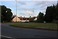
The A30 at the junction of Oxford Road
Image: © David Howard
Taken: 20 Jun 2020
0.06 miles
10
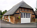
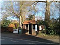
The Old Fire Station, Sutton Scotney
This wonderful thatched barn was brought into use as a fire station for the National Fire Service in 1939 and the crew attended many war-related incidents including a Halifax bomber crash at Hunton Down Farm. On 1st April 1948 the National Fire Service was disbanded and Sutton Scotney fire station became one of the 50 fire stations forming the Hampshire Fire Service. The only thatched fire station in the country, continued in service until 14th October 1972 when the present station a few yards further up Oxford Road was officially opened. The building stands in the car park of the Coach & Horses public house and has been converted into letting accommodation, the three rooms are named Dennis, Bedford and Commer after famous makes of Fire Engine.
The new fire station is next door http://www.geograph.org.uk/photo/430728
Image: © Penny Mayes
Taken: 13 Sep 2005
0.06 miles