IMAGES TAKEN NEAR TO
Oaklands, WINCHESTER, SO21 3HZ
Introduction
This page details the photographs taken nearby to Oaklands, SO21 3HZ by members of the Geograph project.
The Geograph project started in 2005 with the aim of publishing, organising and preserving representative images for every square kilometre of Great Britain, Ireland and the Isle of Man.

There are currently over 7.5m images from over14,400 individuals and you can help contribute to the project by visiting https://www.geograph.org.uk
Image Map (Loading...)


Getting Data...Please wait
Leaflet Map data © OpenStreetMap
Images are licensed for reuse under creativecommons.org/licenses/by-sa/2.0
Notes
- Clicking on the map will re-center to the selected point.
- The higher the marker number, the further away the image location is from the centre of the postcode.
Image Listing (41 Images Found)
Images are licensed for reuse under creativecommons.org/licenses/by-sa/2.0
Image
Details
Distance
1
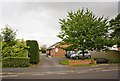
Branch of Gratton Surgey, 67 Downs Road
This is an offshoot of the larger Gratton Surgery in Sutton Scotney. See http://www.grattonsurgery.nhs.uk
Image: © Peter Facey
Taken: 20 Aug 2008
0.07 miles
2
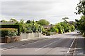
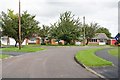
Looking along Downs Road from number 53
Image: © Peter Facey
Taken: 20 Aug 2008
0.07 miles
4
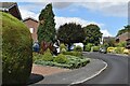
South Wonston Social Club, Downs Road
On the south side of Downs Road between numbers 54 and 66.
Image: © Peter Facey
Taken: 20 Aug 2008
0.10 miles
5
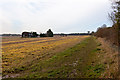
Field on former South Wonston airfield
Looking along the southern edge of the built up area named South Wonston.
Image: © Peter Facey
Taken: 23 Nov 2012
0.11 miles
6
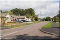
Wrights Close
From its junction with Downs Road.
Image: © Peter Facey
Taken: 20 Aug 2008
0.11 miles
7
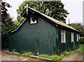
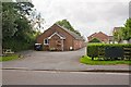
Old Church of St Margaret, South Wonston
Built in 1908.
Image: © Michael FORD
Taken: Unknown
0.14 miles
8
Pavement on south side of Wrights Close
Image: © Peter Facey
Taken: 20 Aug 2008
0.14 miles
9
Junction of Wrights Way and Wrights Close
Contrary to the white lines, Wrights Close is behind the camera and the turning at left. Beyond at right it turns into Wrights Way.
Image: © Peter Facey
Taken: 20 Aug 2008
0.15 miles
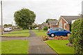
10
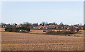
Bungalow and barns on former South Wonston airfield
With South Wonston itself beyond.
Image: © Peter Facey
Taken: 23 Nov 2012
0.15 miles