IMAGES TAKEN NEAR TO
Hornbeam Close, WINCHESTER, SO21 3EA
Introduction
This page details the photographs taken nearby to Hornbeam Close, SO21 3EA by members of the Geograph project.
The Geograph project started in 2005 with the aim of publishing, organising and preserving representative images for every square kilometre of Great Britain, Ireland and the Isle of Man.

There are currently over 7.5m images from over14,400 individuals and you can help contribute to the project by visiting https://www.geograph.org.uk
Image Map
Images are licensed for reuse under creativecommons.org/licenses/by-sa/2.0
Notes
- Clicking on the map will re-center to the selected point.
- The higher the marker number, the further away the image location is from the centre of the postcode.
Image Listing (48 Images Found)
Images are licensed for reuse under creativecommons.org/licenses/by-sa/2.0
Image
Details
Distance
1
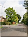
Green space at eastern end of Downs Road, South Wonston
Image: © Peter Facey
Taken: 23 Aug 2008
0.01 miles
2

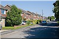
Waverley Drive, South Wonston
Photographer is standing in Green Close.
Image: © Peter Facey
Taken: 22 Aug 2008
0.06 miles
3
Waverley Drive approaches its T-junction with West Hill Road South
Where red garage door is. Turning nearer at right is Paddock Close.
Image: © Peter Facey
Taken: 22 Aug 2008
0.07 miles
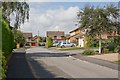
4
Eastern end of Downs Road, South Wonston
Downs Road is the principal road through the village. Here it forms a T-junction with West Hill Road.
Image: © Peter Facey
Taken: 22 Aug 2008
0.08 miles
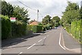
5
West Hill Road North
With Wrights Way at left.
Image: © Peter Facey
Taken: 20 Aug 2008
0.09 miles
6
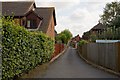
Driveway to Bryher, Catkins, Sanibel House
Off West Hill Road North.
Image: © Peter Facey
Taken: 22 Aug 2008
0.10 miles

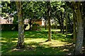
8

Tumulus off Goldfinch Way
It's a very shallow mound surrounded by a beech hedge. The explanatory notice on the nearby long barrow site says that this is a Bronze Age round barrow (2000-1000 BC).
Image: © Peter Facey
Taken: 30 Aug 2008
0.12 miles
9
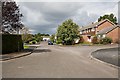
Anders Road
There is housing along both sides of Anders Road. Left foreground is a hammerhead turning point at this closed end. First right is Hunt Close.
Image: © Peter Facey
Taken: 20 Aug 2008
0.13 miles