IMAGES TAKEN NEAR TO
Woodmancott, WINCHESTER, SO21 3BL
Introduction
This page details the photographs taken nearby to SO21 3BL by members of the Geograph project.
The Geograph project started in 2005 with the aim of publishing, organising and preserving representative images for every square kilometre of Great Britain, Ireland and the Isle of Man.

There are currently over 7.5m images from over14,400 individuals and you can help contribute to the project by visiting https://www.geograph.org.uk
Image Map
Images are licensed for reuse under creativecommons.org/licenses/by-sa/2.0
Notes
- Clicking on the map will re-center to the selected point.
- The higher the marker number, the further away the image location is from the centre of the postcode.
Image Listing (24 Images Found)
Images are licensed for reuse under creativecommons.org/licenses/by-sa/2.0
Image
Details
Distance
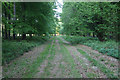
2
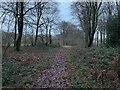
Path in Rownest Wood
Heading towards College Wood.
Image: © Fernweh
Taken: 21 Dec 2022
0.08 miles
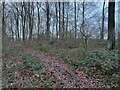
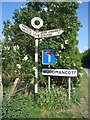
4
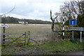
Things at the junction
The junction of lanes on the approach to Woodmancott is a busy place. Apart from the typical rural Hampshire finger post and the no entry sign and the hamlet name, there needs to be a private sign for the fields leading towards College Wood in the north-eastern part of the square.
Image: © Graham Horn
Taken: 21 Mar 2010
0.12 miles
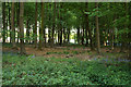
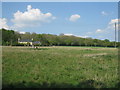
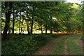
8
College Wood
As seen from the Forestry Commission woodland - Rownest Wood.
Image: © Fernweh
Taken: 26 May 2013
0.14 miles
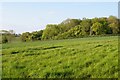
10
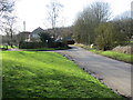
Junction of roads at Calvert House Farm
Looking westward.
Image: © Peter Wood
Taken: 2 Mar 2017
0.15 miles