IMAGES TAKEN NEAR TO
Malpass Road, WINCHESTER, SO21 2QT
Introduction
This page details the photographs taken nearby to Malpass Road, SO21 2QT by members of the Geograph project.
The Geograph project started in 2005 with the aim of publishing, organising and preserving representative images for every square kilometre of Great Britain, Ireland and the Isle of Man.

There are currently over 7.5m images from over14,400 individuals and you can help contribute to the project by visiting https://www.geograph.org.uk
Image Map
Images are licensed for reuse under creativecommons.org/licenses/by-sa/2.0
Notes
- Clicking on the map will re-center to the selected point.
- The higher the marker number, the further away the image location is from the centre of the postcode.
Image Listing (19 Images Found)
Images are licensed for reuse under creativecommons.org/licenses/by-sa/2.0
Image
Details
Distance
1
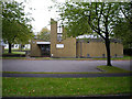
St Andrew's Garrison Church, Worthy Down Camp
The Garrison church, Connaught Road, with family accommodation behind. This is outside the main camp.
Image: © Peter Jordan
Taken: 8 Oct 2005
0.03 miles
2
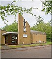
St Andrew's Garrison Church, Worthy Down Camp
Worthy Down Camp is the headquarters of the Adjutant General's Corps.
Image: © Peter Facey
Taken: 31 May 2008
0.03 miles
3
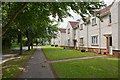
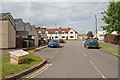
Housing on Connaught Road, Worthy Down Camp
Worthy Down Camp is the headquarters of the Adjutant General's Corps.
Image: © Peter Facey
Taken: 31 May 2008
0.04 miles
4
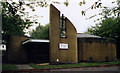
St Andrew, Worthy Down
Built in 1930 as a Garrison Church.
Image: © Michael FORD
Taken: Unknown
0.05 miles
5
Blackwell Road, Worthy Down Camp
Seen from Connaught Road. Worthy Down Camp is the headquarters of the Adjutant General's Corps.
Image: © Peter Facey
Taken: 31 May 2008
0.06 miles
6
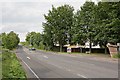
Entrance to Worthy Down Camp
Worthy Down Camp is the headquarters of the Adjutant General's Corps. The turning on the right is Connaught Road which is also a bridleway. When I got here, having walked a considerable distance by an indirect route from Littleton, I realised I was in a sterile area with nearly a kilometre of busy road in each direction with no footway and next to no verge. Luckily, it was only two minutes until the hourly bus service to Winchester.
Image: © Peter Facey
Taken: 31 May 2008
0.14 miles
7
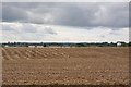
Fields between Lower Road and Worthy Down Camp
Worthy Down Camp is the HQ of the Adjutant General's Corps. There are lots of young men running around these fields, such as the figure seen in red here, doubtless keeping fit.
Image: © Peter Facey
Taken: 21 Aug 2008
0.15 miles
8
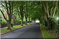
Avenue of trees lining Connaught Road, Worthy Down Camp
Worthy Down Camp is the headquarters of the Adjutant General's Corps. A nice but dark avenue along the western 680 metres of this road.
Image: © Peter Facey
Taken: 31 May 2008
0.15 miles
9
WWII Hampshire - a tour of the defences of RNAS Worthy Down (HMS Kestrel) (38)
-
Pickett-Hamilton fort: DoB ID: S0013769
The site of another Pickett-Hamilton fort lies 500 metres to the west from its companion. It has been retracted and sealed with a covering of concrete, its type and condition is unknown.
Image
Image: © Mike Searle
Taken: 13 Nov 2016
0.15 miles
10
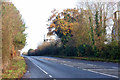
Old A34 near Worth Down
The new road is closely parallel through the hedge to the left.
Image: © Robin Webster
Taken: 29 Nov 2014
0.16 miles