IMAGES TAKEN NEAR TO
Crawley, WINCHESTER, SO21 2PT
Introduction
This page details the photographs taken nearby to SO21 2PT by members of the Geograph project.
The Geograph project started in 2005 with the aim of publishing, organising and preserving representative images for every square kilometre of Great Britain, Ireland and the Isle of Man.

There are currently over 7.5m images from over14,400 individuals and you can help contribute to the project by visiting https://www.geograph.org.uk
Image Map
Images are licensed for reuse under creativecommons.org/licenses/by-sa/2.0
Notes
- Clicking on the map will re-center to the selected point.
- The higher the marker number, the further away the image location is from the centre of the postcode.
Image Listing (89 Images Found)
Images are licensed for reuse under creativecommons.org/licenses/by-sa/2.0
Image
Details
Distance
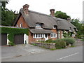
1
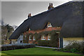
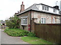
Thatched Cottages - Crawley Near Winchester
Image: © HackBitz
Taken: 21 Mar 2009
0.04 miles
4
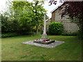
Crawley - War Memorial
Crawley's memorial to her fallen.
Image: © Chris Talbot
Taken: 19 Jun 2010
0.06 miles
5
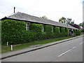
Crawley - Village Hall
This ivy covered hall stands in the middle of the village.
Image: © Chris Talbot
Taken: 19 Jun 2010
0.06 miles
6
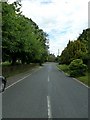
Crawley - Thatched Cottage
A thatched cottage on the main village street.
Image: © Chris Talbot
Taken: 19 Jun 2010
0.06 miles