IMAGES TAKEN NEAR TO
Hursley, WINCHESTER, SO21 2LQ
Introduction
This page details the photographs taken nearby to SO21 2LQ by members of the Geograph project.
The Geograph project started in 2005 with the aim of publishing, organising and preserving representative images for every square kilometre of Great Britain, Ireland and the Isle of Man.

There are currently over 7.5m images from over14,400 individuals and you can help contribute to the project by visiting https://www.geograph.org.uk
Image Map
Images are licensed for reuse under creativecommons.org/licenses/by-sa/2.0
Notes
- Clicking on the map will re-center to the selected point.
- The higher the marker number, the further away the image location is from the centre of the postcode.
Image Listing (10 Images Found)
Images are licensed for reuse under creativecommons.org/licenses/by-sa/2.0
Image
Details
Distance
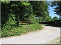
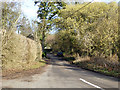
1
Bunstead Lane passes South Parsonage Barn
Image: © Peter Facey
Taken: 12 Sep 2008
0.01 miles
3
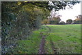
Monarch's Way footpath towards Hursley
Image: © David Martin
Taken: 10 Nov 2013
0.11 miles
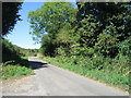
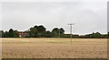
4
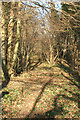
Shelter Belt
A wide belt of trees runs from the top of Yew Hill Image down to Poles Lane Image This is a view north where it crosses the Monarch's Way footpath
Image: © Pierre Terre
Taken: 4 Mar 2006
0.15 miles
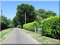
5
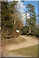
Shawlands Farm
Scots pines at the entrance to Shawlands Farm in Bunstead Lane
Image: © Pierre Terre
Taken: 4 Mar 2006
0.22 miles
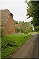
7
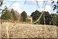
Shawlands Farm
A peep at this handsome but well hidden farmhouse through a recently thrashed hedge
Image: © Pierre Terre
Taken: 4 Mar 2006
0.23 miles
8
Shawlands Farm seen from Monarch's Way at Parsonage Farm
Image: © Peter Facey
Taken: 12 Sep 2008
0.23 miles