IMAGES TAKEN NEAR TO
Greenacres Drive, WINCHESTER, SO21 2HE
Introduction
This page details the photographs taken nearby to Greenacres Drive, SO21 2HE by members of the Geograph project.
The Geograph project started in 2005 with the aim of publishing, organising and preserving representative images for every square kilometre of Great Britain, Ireland and the Isle of Man.

There are currently over 7.5m images from over14,400 individuals and you can help contribute to the project by visiting https://www.geograph.org.uk
Image Map
Images are licensed for reuse under creativecommons.org/licenses/by-sa/2.0
Notes
- Clicking on the map will re-center to the selected point.
- The higher the marker number, the further away the image location is from the centre of the postcode.
Image Listing (9 Images Found)
Images are licensed for reuse under creativecommons.org/licenses/by-sa/2.0
Image
Details
Distance
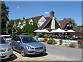
1
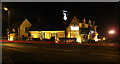
The night Forge
The Old Forge Pub at night. Dates back to the 17th Century.
Image: © Robin Baker
Taken: 29 Jan 2009
0.08 miles
2
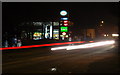
The midnight oil
Esso Petrol Station at Night.
Image: © Robin Baker
Taken: 29 Jan 2009
0.10 miles
3
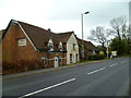
The Old Forge at Otterbourne
A nighttime view is at http://www.geograph.org.uk/photo/1139650.
Image: © Shazz
Taken: 18 Mar 2013
0.11 miles
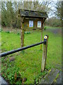
7

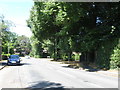
Poles Lane roundabout from Otterborne Road
Image: © John Firth
Taken: 1 Apr 2014
0.17 miles
8
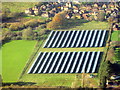
Solar farm at Otterbourne
Looking west on the approach to Southampton Airport. This is one of three Southern Water projects, with about 5000 panels and producing 1.52 MW.
Image: © M J Richardson
Taken: 23 Nov 2017
0.17 miles