IMAGES TAKEN NEAR TO
Kiln Lane, WINCHESTER, SO21 2EN
Introduction
This page details the photographs taken nearby to Kiln Lane, SO21 2EN by members of the Geograph project.
The Geograph project started in 2005 with the aim of publishing, organising and preserving representative images for every square kilometre of Great Britain, Ireland and the Isle of Man.

There are currently over 7.5m images from over14,400 individuals and you can help contribute to the project by visiting https://www.geograph.org.uk
Image Map
Images are licensed for reuse under creativecommons.org/licenses/by-sa/2.0
Notes
- Clicking on the map will re-center to the selected point.
- The higher the marker number, the further away the image location is from the centre of the postcode.
Image Listing (42 Images Found)
Images are licensed for reuse under creativecommons.org/licenses/by-sa/2.0
Image
Details
Distance
1
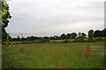
Towards Manor House farm
This view is towards Manor House farm
Image: © Bill Nicholls
Taken: 20 Jun 2008
0.06 miles
2
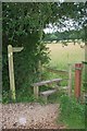
Stile by Manor House farm
This stile is by the entrance to Manor House farm
Image: © Bill Nicholls
Taken: 20 Jun 2008
0.09 miles
3
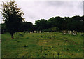
Site of the Old Church of St Matthew, Otterbourne
View of the churchyard.
Image: © Michael FORD
Taken: Unknown
0.11 miles
4
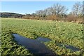
Frozen puddle in field beside Kiln Lane
Still frozen hard in late morning sunlight after a heavy frost last night.
Image: © David Martin
Taken: 3 Jan 2025
0.12 miles
5
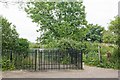
Footpath, and Entrance to Otterbourne Farm, Kiln Lane
I was intrigued by the double layer of locked gates. But the landowner told me that it is only to discourage fly tipping. There are no intact farm buildings here. The footpath at right goes through the site of the now demolished Parish Church of St Matthew.
Image: © Peter Facey
Taken: 29 Jun 2008
0.13 miles
6
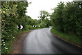
S bends by the entrance
The entrance to Manor House farm is right in the middle of these S bends.
Image: © Bill Nicholls
Taken: 20 Jun 2008
0.13 miles
7
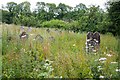
Graves at former St Matthew's Churchyard
Neither the sign board nor most of the graves are entirely upright. The chancel of the former church was demolished in 1971.
Image: © David Martin
Taken: 3 Jan 2025
0.14 miles
8
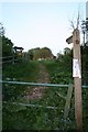
Footpath through the graveyard
Signpost pointing to a footpath which runs through the old graveyard
Image: © Bill Nicholls
Taken: 8 May 2009
0.14 miles
9
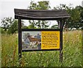
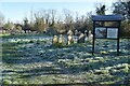
Information board on site of demolished Parish Church of St Matthew, Otterbourne
It tells us that the nave was demolished in 1836 and the chancel in 1971. The graveyard and footings are still there. Accessed via footpath from Kiln Lane.
Image: © Peter Facey
Taken: 29 Jun 2008
0.14 miles
10
Graveyard of demolished Parish Church of St Matthew, Otterbourne
See also Image
Image: © Peter Facey
Taken: 29 Jun 2008
0.14 miles