IMAGES TAKEN NEAR TO
Richmond Park, WINCHESTER, SO21 2DJ
Introduction
This page details the photographs taken nearby to Richmond Park, SO21 2DJ by members of the Geograph project.
The Geograph project started in 2005 with the aim of publishing, organising and preserving representative images for every square kilometre of Great Britain, Ireland and the Isle of Man.

There are currently over 7.5m images from over14,400 individuals and you can help contribute to the project by visiting https://www.geograph.org.uk
Image Map
Images are licensed for reuse under creativecommons.org/licenses/by-sa/2.0
Notes
- Clicking on the map will re-center to the selected point.
- The higher the marker number, the further away the image location is from the centre of the postcode.
Image Listing (4 Images Found)
Images are licensed for reuse under creativecommons.org/licenses/by-sa/2.0
Image
Details
Distance
2
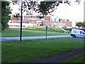
Otterbourne Waterworks
The labs of Otterbourne Waterworks are sited at the end of Waterwork Road, Otterbourne
Image: © Steve Rigg
Taken: 16 Jul 2005
0.06 miles
3
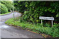
Waterworks Road
Road name, with the waterworks gate in the background.
Image: © David Martin
Taken: 23 Aug 2015
0.07 miles
4
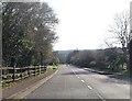
Otterborne Road at Grove Road junction
Looking south
Image: © John Firth
Taken: 1 Apr 2014
0.22 miles