IMAGES TAKEN NEAR TO
Field Way, WINCHESTER, SO21 2AF
Introduction
This page details the photographs taken nearby to Field Way, SO21 2AF by members of the Geograph project.
The Geograph project started in 2005 with the aim of publishing, organising and preserving representative images for every square kilometre of Great Britain, Ireland and the Isle of Man.

There are currently over 7.5m images from over14,400 individuals and you can help contribute to the project by visiting https://www.geograph.org.uk
Image Map (Loading...)


Getting Data...Please wait
Leaflet Map data © OpenStreetMap
Images are licensed for reuse under creativecommons.org/licenses/by-sa/2.0
Notes
- Clicking on the map will re-center to the selected point.
- The higher the marker number, the further away the image location is from the centre of the postcode.
Image Listing (22 Images Found)
Images are licensed for reuse under creativecommons.org/licenses/by-sa/2.0
Image
Details
Distance
1
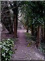
Tree lined path heading west from Compton
Image: © dinglefoot
Taken: 15 Feb 2010
0.14 miles
3
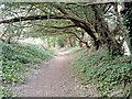
Tree covered path from Compton towards Hursley
Image: © dinglefoot
Taken: 15 Feb 2010
0.16 miles
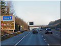
5
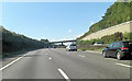
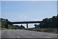
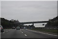
M3 west of Shawford Down
Cliff Way parallels the motorway to the right and Otterbourne Road to the left, the bridge ahead links them.
Image: © Stuart Logan
Taken: 15 Sep 2011
0.17 miles
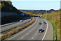
7
The M3 going north
This was taken from the Shepherds Lane bridge and an earlier view is at http://www.geograph.org.uk/photo/360658. The bridge in the distance is in the next grid square to the north.
Image: © Shazz
Taken: 18 Mar 2013
0.18 miles
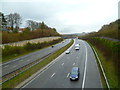
10

M3, near Compton
Looking northbound along the motorway (with the red articulated truck on the southbound carriageway) from the road bridge. Compton is on the left, Shawford on the right and St Catherine's Hill in the distance.
Image: © Jim Champion
Taken: 10 Mar 2007
0.18 miles