IMAGES TAKEN NEAR TO
Churchfields, WINCHESTER, SO21 1NN
Introduction
This page details the photographs taken nearby to Churchfields, SO21 1NN by members of the Geograph project.
The Geograph project started in 2005 with the aim of publishing, organising and preserving representative images for every square kilometre of Great Britain, Ireland and the Isle of Man.

There are currently over 7.5m images from over14,400 individuals and you can help contribute to the project by visiting https://www.geograph.org.uk
Image Map (Loading...)


Getting Data...Please wait
Leaflet Map data © OpenStreetMap
Images are licensed for reuse under creativecommons.org/licenses/by-sa/2.0
Notes
- Clicking on the map will re-center to the selected point.
- The higher the marker number, the further away the image location is from the centre of the postcode.
Image Listing (98 Images Found)
Images are licensed for reuse under creativecommons.org/licenses/by-sa/2.0
Image
Details
Distance
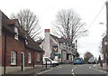
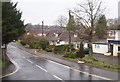
2
Twyford Parish Hall
Available for village and social events.
Image: © Bill Boaden
Taken: 3 Sep 2021
0.08 miles
3
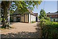
Parish Hall, Twyford
Beyond it (not visible) is the doctors' surgery.
Image: © Peter Facey
Taken: 26 Sep 2008
0.08 miles
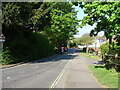
8
Crossroads in Twyford
A small obstacle on the B3335.
Image: © Bill Boaden
Taken: 3 Sep 2021
0.10 miles
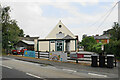
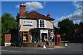
9
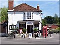
Twyford Post Office
Twyford Post Office and Village Stores sits on the B3335 in the village
Image: © Steve Rigg
Taken: 16 Jul 2005
0.10 miles
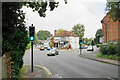
10
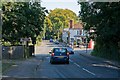
Crossroads on High Street, Twyford
Finch's Lane (left), Hazeley Road (right). The white building is Twyford Post Office & Stores.
Image: © Peter Facey
Taken: 26 Sep 2008
0.10 miles