IMAGES TAKEN NEAR TO
Longwood Dean Lane, WINCHESTER, SO21 1JR
Introduction
This page details the photographs taken nearby to Longwood Dean Lane, SO21 1JR by members of the Geograph project.
The Geograph project started in 2005 with the aim of publishing, organising and preserving representative images for every square kilometre of Great Britain, Ireland and the Isle of Man.

There are currently over 7.5m images from over14,400 individuals and you can help contribute to the project by visiting https://www.geograph.org.uk
Image Map
Images are licensed for reuse under creativecommons.org/licenses/by-sa/2.0
Notes
- Clicking on the map will re-center to the selected point.
- The higher the marker number, the further away the image location is from the centre of the postcode.
Image Listing (5 Images Found)
Images are licensed for reuse under creativecommons.org/licenses/by-sa/2.0
Image
Details
Distance
1
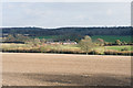
Longwood Dean Farm
Seen from track along Downwards Plantation. Dur Wood is beyond.
Image: © Peter Facey
Taken: 2 Mar 2009
0.02 miles
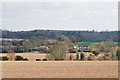
2
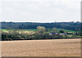
View of Longwood Dean Farm from Forest Copse
Beyond it is the mixed woodland of Dur Wood.
Image: © Peter Facey
Taken: 2 Mar 2009
0.03 miles
4
View towards Mays Farm from Forest Copse
The buildings are (L to R): Rosehill Barn, Mays Farm (behind trees), May Cottages (white). In front of them is Longwood Dean Lane.
Image: © Peter Facey
Taken: 2 Mar 2009
0.14 miles