IMAGES TAKEN NEAR TO
Chilcomb Lane, WINCHESTER, SO21 1HU
Introduction
This page details the photographs taken nearby to Chilcomb Lane, SO21 1HU by members of the Geograph project.
The Geograph project started in 2005 with the aim of publishing, organising and preserving representative images for every square kilometre of Great Britain, Ireland and the Isle of Man.

There are currently over 7.5m images from over14,400 individuals and you can help contribute to the project by visiting https://www.geograph.org.uk
Image Map
Images are licensed for reuse under creativecommons.org/licenses/by-sa/2.0
Notes
- Clicking on the map will re-center to the selected point.
- The higher the marker number, the further away the image location is from the centre of the postcode.
Image Listing (25 Images Found)
Images are licensed for reuse under creativecommons.org/licenses/by-sa/2.0
Image
Details
Distance
1

Lower Chilcomb Farm House & Range Cottage
Range Cottage is in the centre of the picture, with the farm house being to its left. Chilcomb Lane runs past the properties beyond them. The hedge in the foreground separates the field from (to the right of the hedge) the military rifle range.
Image: © Peter Facey
Taken: 8 Mar 2012
0.02 miles
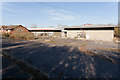
2

Commercial premises on Chilcomb Lane
Seen from Twyford Down. The lane runs left to right beyond the premises.
Image: © Peter Facey
Taken: 8 Mar 2012
0.11 miles
3
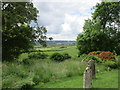
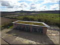
View from the churchyard, Chilcomb
Looking towards Winchester.
Image: © Jonathan Thacker
Taken: 16 Jun 2016
0.18 miles
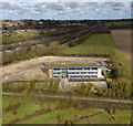
4
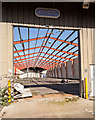
Derelict Pilot HQ & Distribution Centre
Looking into the fourth, easternmost warehouse from the front. The little electric quad bike was presumably introduced by local teenagers after the site ceased to be used by Pilot.
Image: © Peter Facey
Taken: 6 Mar 2012
0.22 miles
5
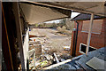
Looking out of derelict Pilot HQ & Distribution Centre
At right can be seen the roof of the passageway connecting this warehouse to the brick-built HQ offices. This picture is looking from the first floor along the front of the warehouses into the car park.
Image: © Peter Facey
Taken: 6 Mar 2012
0.22 miles
6
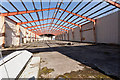
Derelict Pilot HQ & Distribution Centre
The eastern warehouse, one of four on the site. All the roofs of these warehouses have been completely removed, possibly to avoid paying Council Tax.
Image: © Peter Facey
Taken: 6 Mar 2012
0.23 miles
7
Chilcomb Park development nearly finished
Drone photo.
Image: © Peter Facey
Taken: 17 Mar 2019
0.23 miles
8
Derelict Pilot HQ & Distribution Centre
The frontage of the warehouses, with the brick-built HQ office building on the left. [elevated camera position]
Image: © Peter Facey
Taken: 6 Mar 2012
0.23 miles
9
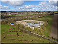
Chilcomb Park development nearly finished
Drone photo.
Image: © Peter Facey
Taken: 17 Mar 2019
0.23 miles
10
Chilcomb Park development nearly finished
Drone photo.
Image: © Peter Facey
Taken: 17 Mar 2019
0.23 miles