IMAGES TAKEN NEAR TO
Weston Grove Road, SOUTHAMPTON, SO19 9UX
Introduction
This page details the photographs taken nearby to Weston Grove Road, SO19 9UX by members of the Geograph project.
The Geograph project started in 2005 with the aim of publishing, organising and preserving representative images for every square kilometre of Great Britain, Ireland and the Isle of Man.

There are currently over 7.5m images from over14,400 individuals and you can help contribute to the project by visiting https://www.geograph.org.uk
Image Map (Loading...)


Getting Data...Please wait
Leaflet Map data © OpenStreetMap
Images are licensed for reuse under creativecommons.org/licenses/by-sa/2.0
Notes
- Clicking on the map will re-center to the selected point.
- The higher the marker number, the further away the image location is from the centre of the postcode.
Image Listing (133 Images Found)
Images are licensed for reuse under creativecommons.org/licenses/by-sa/2.0
Image
Details
Distance
1
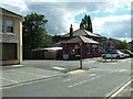
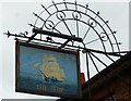
The Ship, Woolston
A view from almost the same position as http://www.geograph.org.uk/photo/1987938
Buses no longer turn here as shown in the earlier view. Instead they carry straight on past the pub along a new stretch of road.
Image: © Rob Candlish
Taken: 1 Sep 2015
0.01 miles
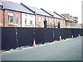
2
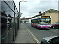
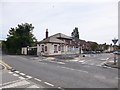
Victoria Road and Weston Grove Road, Woolston
41517 (R417WPX) a First Group Plaxton bodied Dennis Dart SLF 37 seater passing the Victoria Road end of Weston Grove Road, Woolston on route 1A for Weston. When new this vehicle had conventional blinds but it has since been fitted with an electronic dot matrix display. The hoarding on the left clearly shows the developer's branding for the new Centenary Quay project on the old Vosper Thornycroft site.
Image: © Rob Candlish
Taken: 6 Aug 2010
0.02 miles
3
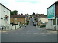
Lake Road, Woolston
Lake Road seen from its junction with Victoria Road. In the background are the houses in Surrey Road. The Portakabin with the yellow door is the office for the coach depot opposite Thornycroft Road.
Image: © Rob Candlish
Taken: 31 Jul 2010
0.02 miles
5
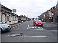
Itchen Way (13)
Here is the first PH to pass on Victoria Road. A previous submission is at http://www.geograph.org.uk/photo/3078057.
Image: © Shazz
Taken: 1 Mar 2013
0.02 miles
6
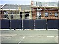
Progress at Centenary Quay
Building work continuing on the site of the former Vosper Thornycroft works in Woolston, seen from Lake Road.
http://www.geograph.org.uk/photo/1983774 and http://www.geograph.org.uk/photo/2329473
are earlier views of this scene taken from much the same viewpoint.
Image: © Rob Candlish
Taken: 29 May 2011
0.02 miles
8
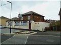
Woolston, The Ship
Community pub at the corner of Victoria Road and Weston Grove Road. L-shaped bar, drinking and eating areas front, left & back; pool, darts, TV, games machines, background music, garden. No cask ale available.
Image: © Mike Faherty
Taken: 11 Aug 2012
0.02 miles
9

Lake Road, Woolston, seen from Victoria Road
Image: © Peter Facey
Taken: 26 May 2007
0.03 miles
10
Progress at Centenary Quay
Looking along Victoria Road. Image http://www.geograph.org.uk/photo/1983768
was taken looking through the gates to the left of this photo, which also appear in http://www.geograph.org.uk/photo/2305586
Image: © Rob Candlish
Taken: 29 May 2011
0.03 miles