IMAGES TAKEN NEAR TO
Keel Road, SOUTHAMPTON, SO19 9UT
Introduction
This page details the photographs taken nearby to Keel Road, SO19 9UT by members of the Geograph project.
The Geograph project started in 2005 with the aim of publishing, organising and preserving representative images for every square kilometre of Great Britain, Ireland and the Isle of Man.

There are currently over 7.5m images from over14,400 individuals and you can help contribute to the project by visiting https://www.geograph.org.uk
Image Map
Images are licensed for reuse under creativecommons.org/licenses/by-sa/2.0
Notes
- Clicking on the map will re-center to the selected point.
- The higher the marker number, the further away the image location is from the centre of the postcode.
Image Listing (206 Images Found)
Images are licensed for reuse under creativecommons.org/licenses/by-sa/2.0
Image
Details
Distance
1
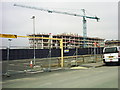
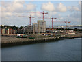
Centenary Quay, Woolston
Construction work underway on the former Vosper Thornycroft site at Woolston. Short lived views of Southampton Water from Victoria Road (where this photo was taken) are now being obscured by buildings again.
Image: © Rob Candlish
Taken: 24 Feb 2011
0.02 miles
2
Vospers shipyard
The last remaining building after the works were transferred to Portsmouth.
Image: © Hugh Venables
Taken: 27 Mar 2007
0.04 miles
4
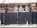
Centenary Quay, Woolston
http://www.geograph.org.uk/photo/1983768 was taken through the gates behind the safety barriers in this photo. Redevelopment of the site is proceeding rapidly.
Image: © Rob Candlish
Taken: 24 Feb 2011
0.04 miles
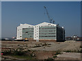
5
Redeveloping Vosper Thornycroft shipyard
Image: © Hugh Venables
Taken: 12 Aug 2014
0.04 miles
7
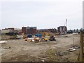
Woolston, building site
Part of extensive former industrial sites on Victoria Road, destined to become Centenary Quay housing. http://www.centenaryquay.co.uk/
Image: © Mike Faherty
Taken: 11 Aug 2012
0.05 miles
8
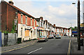
Victoria Road, south of Obelisk Road, Southampton
This road is in a rather run down state. Along its right side is the edge of the former Vosper Thorneycroft shipyard, a large area abutting the river that is due for redevelopment in 2008. It will be interesting to see what effect building lots of modern flats has upon the adjoining streets.
Image: © Peter Facey
Taken: 26 May 2007
0.05 miles
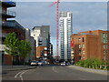
9
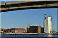
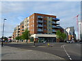
Woolston Centenary Quay development
Residential and commercial waterside development taking shape on the site of the former Vosper Thornycroft shipyard. Seen through the main arch of the Itchen Bridge.
Image: © David Martin
Taken: 12 Jun 2022
0.05 miles
10
Centenary Quay, Woolston
A view of the Centenary Quay development site taken from outside the Victoria Road, Woolston branch of the Co-Op with the Itchen Bridge in the background.
An earlier view of the same scene from almost the same viewpoint is at http://www.geograph.org.uk/photo/1984207
Another earlier view of this scene forms the background to http://www.geograph.org.uk/photo/1983803 as well.
Image: © Rob Candlish
Taken: 30 Mar 2011
0.06 miles