IMAGES TAKEN NEAR TO
John Thornycroft Road, SOUTHAMPTON, SO19 9TQ
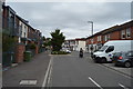
Introduction
This page details the photographs taken nearby to John Thornycroft Road, SO19 9TQ by members of the Geograph project.
The Geograph project started in 2005 with the aim of publishing, organising and preserving representative images for every square kilometre of Great Britain, Ireland and the Isle of Man.

There are currently over 7.5m images from over14,400 individuals and you can help contribute to the project by visiting https://www.geograph.org.uk
Image Map
Images are licensed for reuse under creativecommons.org/licenses/by-sa/2.0
Notes
- Clicking on the map will re-center to the selected point.
- The higher the marker number, the further away the image location is from the centre of the postcode.
Image Listing (170 Images Found)
Images are licensed for reuse under creativecommons.org/licenses/by-sa/2.0
Image
Details
Distance
1
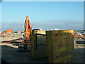
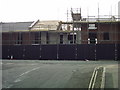
Redevelopment of the Vosper Thornycroft site, Woolston
Construction machinery on the site of the former Vosper Thornycroft works, Victoria Road, Woolston. The buildings in the background are on the opposite side of the River Itchen.
Image: © Rob Candlish
Taken: 28 Jul 2010
0.02 miles
2
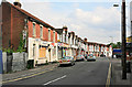
Victoria Road, south of Obelisk Road, Southampton
This road is in a rather run down state. Along its right side is the edge of the former Vosper Thorneycroft shipyard, a large area abutting the river that is due for redevelopment in 2008. It will be interesting to see what effect building lots of modern flats has upon the adjoining streets.
Image: © Peter Facey
Taken: 26 May 2007
0.03 miles
3
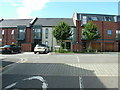
Completion at Centenary Quay
The current view from Lake Road, Woolston looking towards Victoria Road. This shot was taken from the same viewpoint as http://www.geograph.org.uk/photo/2432003
Image: © Rob Candlish
Taken: 1 Sep 2015
0.03 miles
4

Developers' Hoarding, Victoria Road, Woolston
Part of the developers' hoarding on the Victoria Road side of the former Vosper Thornycroft site in Woolston seen from Lake Road. As can be seen it is intended to call the new development Centenary Quay.
Image: © Rob Candlish
Taken: 28 Jul 2010
0.04 miles
6

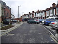
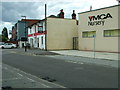
Itchen Way (15)
This is the sign at the second PH passed on Victoria Road.
Image: © Shazz
Taken: 1 Mar 2013
0.04 miles
8
Centenary Quay, Woolston
Building work underway on the site of the former Vosper Thornycroft works in Woolston, seen from Lake Road. Victoria Road runs from left to right in front of the corrugated safety barriers.
The new development, called Centenary Quay, is currently one of the biggest urban regeneration programmes underway in southern England.
http://www.geograph.org.uk/photo/1983774 is an earlier shot of this scene taken from much the same viewpoint.
Image: © Rob Candlish
Taken: 28 Mar 2011
0.05 miles

10
Victoria Road, Woolston
Taken from approximately the same viewpoint as http://www.geograph.org.uk/photo/1985423
showing the changes at this location since 2010.
Image: © Rob Candlish
Taken: 3 Sep 2015
0.05 miles