IMAGES TAKEN NEAR TO
Wallace Road, SOUTHAMPTON, SO19 9JZ
Introduction
This page details the photographs taken nearby to Wallace Road, SO19 9JZ by members of the Geograph project.
The Geograph project started in 2005 with the aim of publishing, organising and preserving representative images for every square kilometre of Great Britain, Ireland and the Isle of Man.

There are currently over 7.5m images from over14,400 individuals and you can help contribute to the project by visiting https://www.geograph.org.uk
Image Map (Loading...)


Getting Data...Please wait
Leaflet Map data © OpenStreetMap
Images are licensed for reuse under creativecommons.org/licenses/by-sa/2.0
Notes
- Clicking on the map will re-center to the selected point.
- The higher the marker number, the further away the image location is from the centre of the postcode.
Image Listing (29 Images Found)
Images are licensed for reuse under creativecommons.org/licenses/by-sa/2.0
Image
Details
Distance
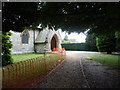
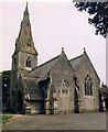
1
Holy Trinity- looking towards the vicarage
Image: © Basher Eyre
Taken: 27 May 2011
0.08 miles
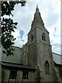

9
Weston, church steeple
Hiding behind vegetation on Weston Lane, the steeple of Holy Trinity Church.
Image: © Mike Faherty
Taken: 11 Aug 2012
0.11 miles
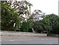
10
Looking across from Holy Trinity, Weston to Barnfield Court
Image: © Basher Eyre
Taken: 27 May 2011
0.12 miles