IMAGES TAKEN NEAR TO
Holland Road, SOUTHAMPTON, SO19 9FW
Introduction
This page details the photographs taken nearby to Holland Road, SO19 9FW by members of the Geograph project.
The Geograph project started in 2005 with the aim of publishing, organising and preserving representative images for every square kilometre of Great Britain, Ireland and the Isle of Man.

There are currently over 7.5m images from over14,400 individuals and you can help contribute to the project by visiting https://www.geograph.org.uk
Image Map
Images are licensed for reuse under creativecommons.org/licenses/by-sa/2.0
Notes
- Clicking on the map will re-center to the selected point.
- The higher the marker number, the further away the image location is from the centre of the postcode.
Image Listing (141 Images Found)
Images are licensed for reuse under creativecommons.org/licenses/by-sa/2.0
Image
Details
Distance
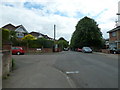
1
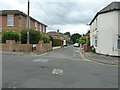
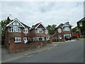
Looking from Church Road into Holland Road
Image: © Basher Eyre
Taken: 27 May 2011
0.01 miles
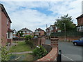
2
Looking from Longmore Avenue across Church Road towards Holland Road
Image: © Basher Eyre
Taken: 27 May 2011
0.04 miles
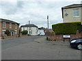
3
Junction of Church Road and Longmore Crescent
Image: © Basher Eyre
Taken: 27 May 2011
0.04 miles
4
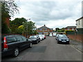
Looking from Longmore Avenue towards Church Road
Image: © Basher Eyre
Taken: 27 May 2011
0.04 miles
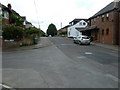
5
Junction of Church Road and Longmore Avenue
Image: © Basher Eyre
Taken: 27 May 2011
0.04 miles
6
Looking from Church Road into Longmore Crescent
Image: © Basher Eyre
Taken: 27 May 2011
0.06 miles
7
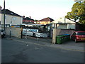
Coach depot, Lake Road, Woolston
Coach depot in Lake Road, Woolston opposite its junction with Thornycroft Road.
Image: © Rob Candlish
Taken: 28 Jul 2010
0.06 miles
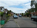
10

Lake Road, Woolston, seen from Victoria Road
Image: © Peter Facey
Taken: 26 May 2007
0.08 miles