IMAGES TAKEN NEAR TO
Glen Road, SOUTHAMPTON, SO19 9EJ
Introduction
This page details the photographs taken nearby to Glen Road, SO19 9EJ by members of the Geograph project.
The Geograph project started in 2005 with the aim of publishing, organising and preserving representative images for every square kilometre of Great Britain, Ireland and the Isle of Man.

There are currently over 7.5m images from over14,400 individuals and you can help contribute to the project by visiting https://www.geograph.org.uk
Image Map
Images are licensed for reuse under creativecommons.org/licenses/by-sa/2.0
Notes
- Clicking on the map will re-center to the selected point.
- The higher the marker number, the further away the image location is from the centre of the postcode.
Image Listing (126 Images Found)
Images are licensed for reuse under creativecommons.org/licenses/by-sa/2.0
Image
Details
Distance
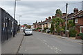
1
Woolston, Victoria Road
Modern housing, left; Victorian, right.
Image: © Mike Faherty
Taken: 11 Aug 2012
0.03 miles
3

Drawings by Woolston Infant School pupils
These drawings by Woolston Infant School pupils are on enamel plates beside the southern gate of the Centenary Quay development off Victoria Road. Their theme is that building sites are dangerous places and not playgrounds.
Image: © Rob Candlish
Taken: 29 Jul 2010
0.04 miles
4
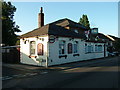
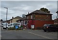
The Ship Inn, Victoria Road, Woolston
Public house on the corner of Weston Grove Road and Victoria Road, Woolston.
Image: © Rob Candlish
Taken: 28 Jul 2010
0.04 miles
5
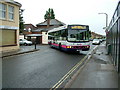
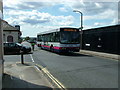
Bus to the city
First Group 66128 (S118JTP) a Wrights bodied Volvo B10BLE turning into Victoria Road, Woolston from Weston Grove Road on its way to Southampton city centre with route 1. The Ship Inn is immediately behind the bus.
Image: © Rob Candlish
Taken: 31 Jul 2010
0.05 miles
6
Victoria Road and Weston Grove Road, Woolston
First Group 66128(S118JTP), a Wrights bodied Volvo B10BLE, passing the end of Weston Grove Road, Woolston on a route 1A journey from Weston to Southampton city centre. Route 1 from Weston re-joins route 1A here, having diverged from it at Archery Road, and the two routes then run in parallel via the Itchen Bridge to the city centre.
Image: © Rob Candlish
Taken: 5 Aug 2010
0.05 miles
7
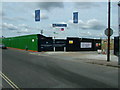
Former main gate to Vosper Thornycroft, Victoria Road, Woolston
The former main gate to the Vosper Thornycroft works in Woolston is now the northern gate to Centenary Quay, a new development being built on the site of the old works.
Image: © Rob Candlish
Taken: 29 Jul 2010
0.05 miles
8
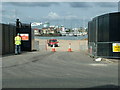
Southern gate to Centenary Quay off Victoria Road
Centenary Quay is a major urban regeneration programme to redevelop the former Vosper Thornycroft shipyard beside the River Itchen in Woolston. Over the next 10 years 1,620 new homes (1,472 flats and 148 town houses) will be built on the 33 acre (13.35 hectare) site together with a food superstore, offices, shops, a hotel, restaurants, cafes and a "marine employment quarter". This development will increase the population of Woolston by almost 20% and is expected to cost £500m to complete.
Image: © Rob Candlish
Taken: 29 Jul 2010
0.06 miles
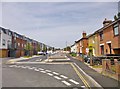
10
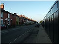
Houses in Victoria Road, Woolston
Houses in Victoria Road, Woolston on the left and the black painted developers hoarding around the former Vosper Thornycroft works to the right. The Itchen Estuary and Southampton Water are just visible at the end of the road.
Image: © Rob Candlish
Taken: 28 Jul 2010
0.06 miles