IMAGES TAKEN NEAR TO
Hawkhurst Close, SOUTHAMPTON, SO19 9AX
Introduction
This page details the photographs taken nearby to Hawkhurst Close, SO19 9AX by members of the Geograph project.
The Geograph project started in 2005 with the aim of publishing, organising and preserving representative images for every square kilometre of Great Britain, Ireland and the Isle of Man.

There are currently over 7.5m images from over14,400 individuals and you can help contribute to the project by visiting https://www.geograph.org.uk
Image Map
Images are licensed for reuse under creativecommons.org/licenses/by-sa/2.0
Notes
- Clicking on the map will re-center to the selected point.
- The higher the marker number, the further away the image location is from the centre of the postcode.
Image Listing (6 Images Found)
Images are licensed for reuse under creativecommons.org/licenses/by-sa/2.0
Image
Details
Distance
1
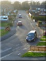
Looking along the northern section of Tenterton Avenue
This was taken from the footbridge over the railway.
Image: © Shazz
Taken: 15 Feb 2013
0.05 miles
3

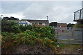
Millers Pond, Sholing Common
Named after the mill that once stood next to the pond
Image: © David Mainwood
Taken: 2 Jul 2005
0.18 miles
4
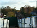
View of railway line from footbridge north of Tenterton Avenue
Tickleford Wood is beyond the houses.
Image: © Shazz
Taken: 15 Feb 2013
0.19 miles
6
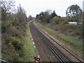
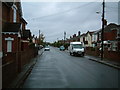
Railway heading past Newtown
From Upper Weston Lane bridge the railway heading past Newtown
Image: © Shaun Ferguson
Taken: 16 Mar 2012
0.24 miles