IMAGES TAKEN NEAR TO
West Road, SOUTHAMPTON, SO19 9AJ
Introduction
This page details the photographs taken nearby to West Road, SO19 9AJ by members of the Geograph project.
The Geograph project started in 2005 with the aim of publishing, organising and preserving representative images for every square kilometre of Great Britain, Ireland and the Isle of Man.

There are currently over 7.5m images from over14,400 individuals and you can help contribute to the project by visiting https://www.geograph.org.uk
Image Map (Loading...)


Getting Data...Please wait
Leaflet Map data © OpenStreetMap
Images are licensed for reuse under creativecommons.org/licenses/by-sa/2.0
Notes
- Clicking on the map will re-center to the selected point.
- The higher the marker number, the further away the image location is from the centre of the postcode.
Image Listing (74 Images Found)
Images are licensed for reuse under creativecommons.org/licenses/by-sa/2.0
Image
Details
Distance
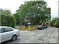
1
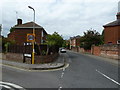
Junction of West Road and Florence Road
Image: © Basher Eyre
Taken: 27 May 2011
0.03 miles
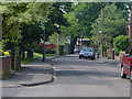
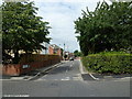
3
Looking from Florence Road into West Road
and from there over to Hazeleigh Avenue.
Image: © Basher Eyre
Taken: 27 May 2011
0.04 miles
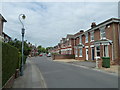
4
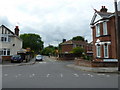
Junction of West Road and Hazeleigh Avenue
Looking towards Florence Road.
Image: © Basher Eyre
Taken: 27 May 2011
0.05 miles
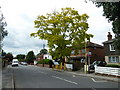
5
Looking along Florence Road towards Woolston Infant School
Image: © Basher Eyre
Taken: 27 May 2011
0.06 miles
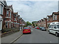
6
Lyndock Place Southampton.
Lyndock Place. A residential road in Woolston Southampton.
Image: © Tony Grant
Taken: 25 Apr 2002
0.08 miles
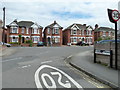
9
Looking from Obelisk Road into West Road
Image: © Basher Eyre
Taken: 27 May 2011
0.09 miles
