IMAGES TAKEN NEAR TO
Lynden Gate, SOUTHAMPTON, SO19 8TH
Introduction
This page details the photographs taken nearby to Lynden Gate, SO19 8TH by members of the Geograph project.
The Geograph project started in 2005 with the aim of publishing, organising and preserving representative images for every square kilometre of Great Britain, Ireland and the Isle of Man.

There are currently over 7.5m images from over14,400 individuals and you can help contribute to the project by visiting https://www.geograph.org.uk
Image Map (Loading...)


Getting Data...Please wait
Leaflet Map data © OpenStreetMap
Images are licensed for reuse under creativecommons.org/licenses/by-sa/2.0
Notes
- Clicking on the map will re-center to the selected point.
- The higher the marker number, the further away the image location is from the centre of the postcode.
Image Listing (14 Images Found)
Images are licensed for reuse under creativecommons.org/licenses/by-sa/2.0
Image
Details
Distance
1
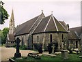
St Mary, Sholing
Grade 2 listed building erected in 1866.
Image: © Michael FORD
Taken: Unknown
0.10 miles
2
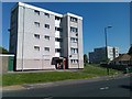
Local authority-built flats in Kathleen Road
Image: © David Martin
Taken: 28 May 2012
0.14 miles
3
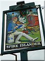
Sign at "Spike Islander" PH
For an explanation of the name see http://stephensays.wordpress.com/2011/04/24/the-test-the-itchen-and-spike-island/.
Image: © Shazz
Taken: 1 Mar 2013
0.15 miles
4
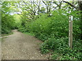
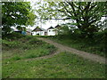
Shoreburs Greenway waymark post
Shoreburs Greenway links Weston Shore to Bursledon Road. It includes a wide range of different environments from formal parkland, play areas and ponds to woodland, heather and gorse scrub.
Image: © Christine Johnstone
Taken: 23 Apr 2022
0.19 miles
5
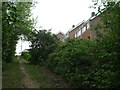
Path from Willow Tree Walk
To Shoreburs Greenway, which links Weston Shore to Bursledon Road. It includes a wide range of different environments from formal parkland, play areas and ponds to woodland, heather and gorse scrub.
Image: © Christine Johnstone
Taken: 23 Apr 2022
0.19 miles
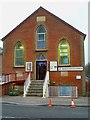
6
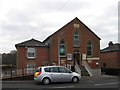
Sholing Baptist Church, Southampton
Church with ambulance car outside
Image: © Alex McGregor
Taken: 23 Mar 2010
0.19 miles
7
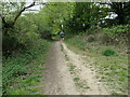
Path from Sunvale Close
To Shoreburs Greenway, which links Weston Shore to Bursledon Road. It includes a wide range of different environments from formal parkland, play areas and ponds to woodland, heather and gorse scrub.
Image: © Christine Johnstone
Taken: 23 Apr 2022
0.20 miles
8
Jogger, Shoreburs Greenway
Shoreburs Greenway is well-used by local people. It links Weston Shore to Bursledon Road and includes a wide range of different environments from formal parkland, play areas and ponds to woodland, heather and gorse scrub.
Image: © Christine Johnstone
Taken: 23 Apr 2022
0.20 miles
9
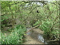
Downstream from a footbridge, Shoreburs Greenway
The Greenway here is in the narrow wooded valley of a spring-fed stream.
Image: © Christine Johnstone
Taken: 23 Apr 2022
0.23 miles
10
Sholing Baptist Chapel and Mission Hall
For a 2010 picture see http://www.geograph.org.uk/photo/1766608.
Image: © Shazz
Taken: 1 Mar 2013
0.23 miles