IMAGES TAKEN NEAR TO
Furze Close, SOUTHAMPTON, SO19 8PF
Introduction
This page details the photographs taken nearby to Furze Close, SO19 8PF by members of the Geograph project.
The Geograph project started in 2005 with the aim of publishing, organising and preserving representative images for every square kilometre of Great Britain, Ireland and the Isle of Man.

There are currently over 7.5m images from over14,400 individuals and you can help contribute to the project by visiting https://www.geograph.org.uk
Image Map
Images are licensed for reuse under creativecommons.org/licenses/by-sa/2.0
Notes
- Clicking on the map will re-center to the selected point.
- The higher the marker number, the further away the image location is from the centre of the postcode.
Image Listing (9 Images Found)
Images are licensed for reuse under creativecommons.org/licenses/by-sa/2.0
Image
Details
Distance
2
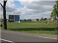
Veracity Recreation Ground
'Veracity' and 'Barclays' on the same sign. Perhaps their LIBOR team should have learnt from their football sponsorship team.
Image: © Hugh Venables
Taken: 5 May 2013
0.18 miles
4
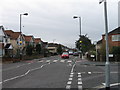
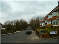
Zebra crossing Middle Road, Southampton
Viewed from Ruby Road
Image: © Alex McGregor
Taken: 23 Mar 2010
0.19 miles
7
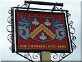
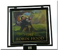
Sign at The Chamberlayne Arms
The public house is shown at http://www.geograph.org.uk/photo/3112056. It is still closed.
Image: © Shazz
Taken: 1 Mar 2013
0.19 miles
8
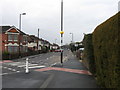
Zebra crossing, Deacon Road, Southampton
Viewed from Ruby Road
Image: © Alex McGregor
Taken: 23 Mar 2010
0.23 miles
9
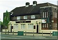
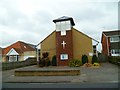
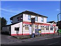
Art Deco pub, "Merry Oak", Spring Road / Deacon Road, Merry Oak
With its flat roof towers, with tall narrow windows, and steep sloping roof, this striking public house blends Art Deco into this residential area.
Image: © Alan Cooper
Taken: Unknown
0.25 miles