IMAGES TAKEN NEAR TO
Effingham Gardens, SOUTHAMPTON, SO19 8GF
Introduction
This page details the photographs taken nearby to Effingham Gardens, SO19 8GF by members of the Geograph project.
The Geograph project started in 2005 with the aim of publishing, organising and preserving representative images for every square kilometre of Great Britain, Ireland and the Isle of Man.

There are currently over 7.5m images from over14,400 individuals and you can help contribute to the project by visiting https://www.geograph.org.uk
Image Map
Images are licensed for reuse under creativecommons.org/licenses/by-sa/2.0
Notes
- Clicking on the map will re-center to the selected point.
- The higher the marker number, the further away the image location is from the centre of the postcode.
Image Listing (15 Images Found)
Images are licensed for reuse under creativecommons.org/licenses/by-sa/2.0
Image
Details
Distance
1
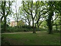
Houses on Banbury Avenue, from Shoreburs Greenway
Shoreburs Greenway links Weston Shore to Bursledon Road. It includes a wide range of different environments from formal parkland, play areas and ponds to woodland, heather and gorse scrub.
Image: © Christine Johnstone
Taken: 23 Apr 2022
0.08 miles
2
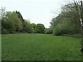
Weston Common, Shoreburs Greenway
Shoreburs Greenway links Weston Shore to Bursledon Road. It includes a wide range of different environments from formal parkland, play areas and ponds to woodland, heather and gorse scrub.
Image: © Christine Johnstone
Taken: 23 Apr 2022
0.09 miles
3
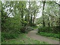
Footbridge near Imber Way, Shoreburs Greenway
Shoreburs Greenway links Weston Shore to Bursledon Road. It includes a wide range of different environments from formal parkland, play areas and ponds to woodland, heather and gorse scrub.
Image: © Christine Johnstone
Taken: 23 Apr 2022
0.11 miles
4
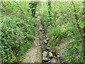
Sandbagged stream, Shoreburs Greenway
Many of the concreted sandbags which reinforce the bank have fallen onto the stream bed.
Image: © Christine Johnstone
Taken: 23 Apr 2022
0.11 miles
5
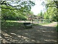
Play area, Shoreburs Greenway
Shoreburs Greenway links Weston Shore to Bursledon Road. It includes a wide range of different environments from formal parkland, play areas and ponds to woodland, heather and gorse scrub.
Image: © Christine Johnstone
Taken: 23 Apr 2022
0.13 miles
6
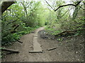
Boarded path, Shoreburs Greenway
Shoreburs Greenway links Weston Shore to Bursledon Road. It includes a wide range of different environments from formal parkland, play areas and ponds to woodland, heather and gorse scrub.
Image: © Christine Johnstone
Taken: 23 Apr 2022
0.15 miles
7
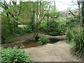
Informal footbridge, Shoreburs Greenway
A fallen tree bridges a nameless stream.
Image: © Christine Johnstone
Taken: 23 Apr 2022
0.16 miles
8
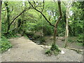
Rope swing over a stream, Shoreburs Greenway
Shoreburs Greenway links Weston Shore to Bursledon Road. It includes a wide range of different environments from formal parkland, play areas and ponds to woodland, heather and gorse scrub.
Image: © Christine Johnstone
Taken: 23 Apr 2022
0.17 miles
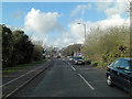
10

A3024 Bursledon Road at Hinkler Road lights
Hinkler Road gives access to a large residential area.
Image: © Robin Webster
Taken: 16 Sep 2018
0.19 miles