IMAGES TAKEN NEAR TO
Somerford Close, SOUTHAMPTON, SO19 7RL
Introduction
This page details the photographs taken nearby to Somerford Close, SO19 7RL by members of the Geograph project.
The Geograph project started in 2005 with the aim of publishing, organising and preserving representative images for every square kilometre of Great Britain, Ireland and the Isle of Man.

There are currently over 7.5m images from over14,400 individuals and you can help contribute to the project by visiting https://www.geograph.org.uk
Image Map
Images are licensed for reuse under creativecommons.org/licenses/by-sa/2.0
Notes
- Clicking on the map will re-center to the selected point.
- The higher the marker number, the further away the image location is from the centre of the postcode.
Image Listing (22 Images Found)
Images are licensed for reuse under creativecommons.org/licenses/by-sa/2.0
Image
Details
Distance
1
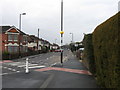
Zebra crossing, Deacon Road, Southampton
Viewed from Ruby Road
Image: © Alex McGregor
Taken: 23 Mar 2010
0.13 miles
2
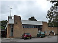
Wesley Chapel, White's Road
Part of the Bitterne Anglican- Methodist Partnership
Image: © Basher Eyre
Taken: 29 Aug 2014
0.15 miles
3
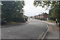
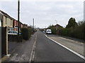
Whites Road
Giving access to the residential areas to the south of Bitterne.
It is thought that the road originally included an apostrophe as in White's Road, but this is not included in any road signs. Other references may show it either with or without the apostrophe.
Image: © Bill Boaden
Taken: 29 Sep 2016
0.16 miles
4
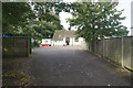
Bitterne Parish Church Hall
This has been a supplementary part of the church premises for many years.
Image: © Bill Boaden
Taken: 29 Sep 2016
0.18 miles
5
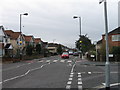
Zebra crossing Middle Road, Southampton
Viewed from Ruby Road
Image: © Alex McGregor
Taken: 23 Mar 2010
0.18 miles
7
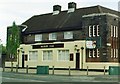
Art Deco pub, "Merry Oak", Spring Road / Deacon Road, Merry Oak
With its flat roof towers, with tall narrow windows, and steep sloping roof, this striking public house blends Art Deco into this residential area.
Image: © Alan Cooper
Taken: Unknown
0.19 miles
8
Ruby Road, Southampton
Viewed from Deacon Road
Image: © Alex McGregor
Taken: 23 Mar 2010
0.19 miles
9
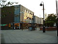
Sainsbury's Supermarket, Bitterne, Southampton
The rather Brutalist Sainsbury's supermarket in Bitterne Precinct.
Image: © GaryReggae
Taken: 13 Jul 2005
0.20 miles
10
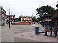
Red Lion in Bitterne Precinct Southampton
Thirty or so years ago this was a very busy junction of two main roads, but with the construction of the Bitterne Bypass, it is now a pedestrian precinct, with the old Red Lion an oasis of calm.
Image: © Dave Jacobs
Taken: 9 Jun 2005
0.20 miles