IMAGES TAKEN NEAR TO
Caerleon Drive, SOUTHAMPTON, SO19 5LH
Introduction
This page details the photographs taken nearby to Caerleon Drive, SO19 5LH by members of the Geograph project.
The Geograph project started in 2005 with the aim of publishing, organising and preserving representative images for every square kilometre of Great Britain, Ireland and the Isle of Man.

There are currently over 7.5m images from over14,400 individuals and you can help contribute to the project by visiting https://www.geograph.org.uk
Image Map
Images are licensed for reuse under creativecommons.org/licenses/by-sa/2.0
Notes
- Clicking on the map will re-center to the selected point.
- The higher the marker number, the further away the image location is from the centre of the postcode.
Image Listing (11 Images Found)
Images are licensed for reuse under creativecommons.org/licenses/by-sa/2.0
Image
Details
Distance
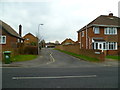
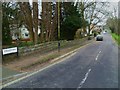
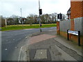
1
Caerleon Avenue, Southampton
Viewed from Upper Deacon Road
Image: © Alex McGregor
Taken: 23 Mar 2010
0.10 miles
4
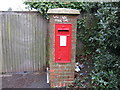
Post Box, Upper Deacon Road, Southampton
Opposite Caerleon Avenue
Image: © Alex McGregor
Taken: 23 Mar 2010
0.13 miles
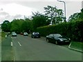
5
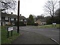
Barnes Road, Southampton
Viewed from Upper Deacon Road
Image: © Alex McGregor
Taken: 23 Mar 2010
0.16 miles
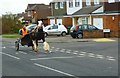
6
Looking from the end of North East Road to Donkey Common
Image: © Shazz
Taken: 1 Mar 2013
0.17 miles
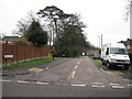
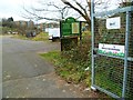
7
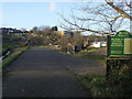
Bitterne Road East allotments
Off Upper Deacon Road the Bitterne Road East allotments
Image: © Shaun Ferguson
Taken: 30 Jan 2013
0.18 miles