IMAGES TAKEN NEAR TO
Spring Road, SOUTHAMPTON, SO19 2QX
Introduction
This page details the photographs taken nearby to Spring Road, SO19 2QX by members of the Geograph project.
The Geograph project started in 2005 with the aim of publishing, organising and preserving representative images for every square kilometre of Great Britain, Ireland and the Isle of Man.

There are currently over 7.5m images from over14,400 individuals and you can help contribute to the project by visiting https://www.geograph.org.uk
Image Map (Loading...)


Getting Data...Please wait
Leaflet Map data © OpenStreetMap
Images are licensed for reuse under creativecommons.org/licenses/by-sa/2.0
Notes
- Clicking on the map will re-center to the selected point.
- The higher the marker number, the further away the image location is from the centre of the postcode.
Image Listing (14 Images Found)
Images are licensed for reuse under creativecommons.org/licenses/by-sa/2.0
Image
Details
Distance
1
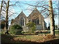
Peartree Green Church
View of the back of the church
Image: © Ruth Touhey
Taken: 13 Feb 2005
0.17 miles
2

Peartree Green Church
The church, called Jesus chapel, on Peartree Green, is a small structure, erected 1620, and repaired in 1822: it has a chancel, nave, north aisle, added in 1846, and organ chamber in 1866, and south transept.
Image: © David Mainwood
Taken: 2 May 2004
0.17 miles

4
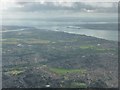
Southampton : Southampton Scenery
Looking out across Southampton and the Solent with the Isle of Wight in view.
Image: © Lewis Clarke
Taken: 23 Aug 2012
0.17 miles
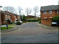
5
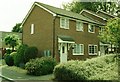
Flats off Cranbury Road, Sholing
Suburban housing, Southampton.
Image: © Christine Johnstone
Taken: 23 Apr 2022
0.19 miles
7
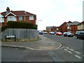
Modern housing Squirrel Drive, Sholing
Situated in the small valley with the stream running through to Miller's Pond. This was a rural area until the rapid expansion of Southampton beginning in the Victorian era. Victorian villas in this area are now in turn being pulled down and replaced with modern flats. But much of the valley survived as allotments but with the pressure for housing they are being built over as well as illustrated in this photo.
Image: © Alan Cooper
Taken: Unknown
0.20 miles
8
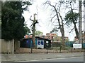
Looking north on Middle Road
The Baptist chapel is the large building on the right.
Image: © Shazz
Taken: 1 Mar 2013
0.21 miles
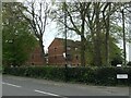
9
Scout hut, Spring Road, Sholing
Home to Southampton's 14th Itchen South [St Mary's] scouts.
Image: © Christine Johnstone
Taken: 23 Apr 2022
0.21 miles
10
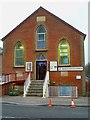
Sholing Baptist Chapel and Mission Hall
For a 2010 picture see http://www.geograph.org.uk/photo/1766608.
Image: © Shazz
Taken: 1 Mar 2013
0.22 miles