IMAGES TAKEN NEAR TO
Cheddar Close, SOUTHAMPTON, SO19 2EZ
Introduction
This page details the photographs taken nearby to Cheddar Close, SO19 2EZ by members of the Geograph project.
The Geograph project started in 2005 with the aim of publishing, organising and preserving representative images for every square kilometre of Great Britain, Ireland and the Isle of Man.

There are currently over 7.5m images from over14,400 individuals and you can help contribute to the project by visiting https://www.geograph.org.uk
Image Map
Images are licensed for reuse under creativecommons.org/licenses/by-sa/2.0
Notes
- Clicking on the map will re-center to the selected point.
- The higher the marker number, the further away the image location is from the centre of the postcode.
Image Listing (70 Images Found)
Images are licensed for reuse under creativecommons.org/licenses/by-sa/2.0
Image
Details
Distance
1
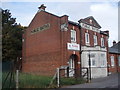
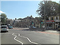
Former Public Baths at Woolston
Now an Advice Centre, it is amazing such a peaceful road can be found such a short distance from the busy A road.
Image: © Basher Eyre
Taken: 13 Oct 2007
0.11 miles
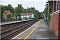
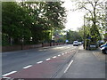
4
A3025 north of The Bridge public house
Image: © Stuart Logan
Taken: 15 Sep 2011
0.12 miles
6
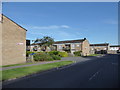
2016: a year on Geograph (Day 195)
Approaching the junction of Poole Road and Drummond Court
Image: © Basher Eyre
Taken: 13 Jul 2016
0.12 miles
8
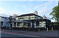
The Cricketers Arms, Woolston
On Portsmouth Road.
See Image] for sign.
Image: © JThomas
Taken: 27 Apr 2022
0.13 miles
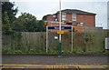
9
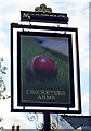
Sign for the Cricketers Arms, Woolston
See Image] for context.
Image: © JThomas
Taken: 27 Apr 2022
0.13 miles