IMAGES TAKEN NEAR TO
Dawson Road, SOUTHAMPTON, SO19 0SP
Introduction
This page details the photographs taken nearby to Dawson Road, SO19 0SP by members of the Geograph project.
The Geograph project started in 2005 with the aim of publishing, organising and preserving representative images for every square kilometre of Great Britain, Ireland and the Isle of Man.

There are currently over 7.5m images from over14,400 individuals and you can help contribute to the project by visiting https://www.geograph.org.uk
Image Map (Loading...)


Getting Data...Please wait
Leaflet Map data © OpenStreetMap
Images are licensed for reuse under creativecommons.org/licenses/by-sa/2.0
Notes
- Clicking on the map will re-center to the selected point.
- The higher the marker number, the further away the image location is from the centre of the postcode.
Image Listing (17 Images Found)
Images are licensed for reuse under creativecommons.org/licenses/by-sa/2.0
Image
Details
Distance
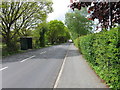
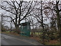
4
B3033 Botley Road
Seen immediately after leaving the Portsmouth Road.
Image: © Stuart Logan
Taken: 10 Jan 2013
0.15 miles
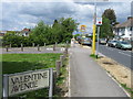
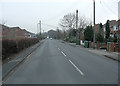
5
Botley Road, Newtown, Hampshire
Seen from the junction with Portsmouth Road.
Image: © Peter Trimming
Taken: 2 Mar 2010
0.16 miles
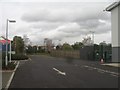
6

Southampton : Southampton Scenery
Looking down towards Southampton and the surroundings of Sholing.
Image: © Lewis Clarke
Taken: 23 Aug 2012
0.17 miles