IMAGES TAKEN NEAR TO
Shop Lane, SOUTHAMPTON, SO19 0QS
Introduction
This page details the photographs taken nearby to Shop Lane, SO19 0QS by members of the Geograph project.
The Geograph project started in 2005 with the aim of publishing, organising and preserving representative images for every square kilometre of Great Britain, Ireland and the Isle of Man.

There are currently over 7.5m images from over14,400 individuals and you can help contribute to the project by visiting https://www.geograph.org.uk
Image Map (Loading...)


Getting Data...Please wait
Leaflet Map data © OpenStreetMap
Images are licensed for reuse under creativecommons.org/licenses/by-sa/2.0
Notes
- Clicking on the map will re-center to the selected point.
- The higher the marker number, the further away the image location is from the centre of the postcode.
Image Listing (8 Images Found)
Images are licensed for reuse under creativecommons.org/licenses/by-sa/2.0
Image
Details
Distance
1
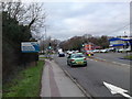
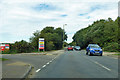
Enter Southampton via Hightown
Here you enter Southampton from Eastleigh district via Hightown.
Image: © dinglefoot
Taken: 31 Dec 2009
0.14 miles
4
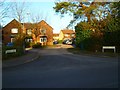
Looking from Montague Avenue into Brooms Grove
Image: © Basher Eyre
Taken: 2 Dec 2014
0.15 miles

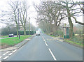
7
A3024 Bursledon Road at site entrance
A Taylor Wimpey building site access to the left - Kingfisher Grange and Kestrel Park. Residents are advised to enter from Hamble Lane.
Image: © Robin Webster
Taken: 16 Sep 2018
0.24 miles
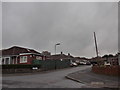
8

Footpath & Car Boot exit
Taken from Bursledon Road the footpath widens considerably to double up as a car boot sale second exit.
Image: © dinglefoot
Taken: 31 Dec 2009
0.24 miles