IMAGES TAKEN NEAR TO
Orpen Road, SOUTHAMPTON, SO19 0DU
Introduction
This page details the photographs taken nearby to Orpen Road, SO19 0DU by members of the Geograph project.
The Geograph project started in 2005 with the aim of publishing, organising and preserving representative images for every square kilometre of Great Britain, Ireland and the Isle of Man.

There are currently over 7.5m images from over14,400 individuals and you can help contribute to the project by visiting https://www.geograph.org.uk
Image Map (Loading...)


Getting Data...Please wait
Leaflet Map data © OpenStreetMap
Images are licensed for reuse under creativecommons.org/licenses/by-sa/2.0
Notes
- Clicking on the map will re-center to the selected point.
- The higher the marker number, the further away the image location is from the centre of the postcode.
Image Listing (13 Images Found)
Images are licensed for reuse under creativecommons.org/licenses/by-sa/2.0
Image
Details
Distance
1
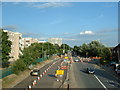
Bursledon Road, Southampton
Bursledon Road (A3024), one of the main routes out of Southampton. Despite it being a dual carriageway, there is a 30 mph speed limit along most of the way. This shot is looking South East and shows part of the Thornhill/Hightown estate.
Image: © GaryReggae
Taken: 21 Jul 2005
0.10 miles
2
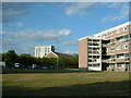
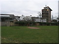
Hightown Estate, Southampton
Part of the Hightown Estate showing Dumbleton's Tower and a typical block of walk up flats. There are dozens of blocks of this design throughout Southampton.
Image: © GaryReggae
Taken: 21 Jul 2005
0.10 miles
3
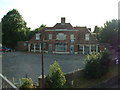
Derelict pub, Thornhill, Southampton
A derelict and heavily vandalised pub off Bursledon Road.
Image: © GaryReggae
Taken: 21 Jul 2005
0.10 miles
4
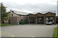
Hightown fire station
Hightown fire station, 35 Coates Road, Sholing, Hampshire
Image: © Kevin Hale
Taken: 11 Nov 2006
0.15 miles
5
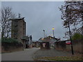
Ivy Dene Play Area
Off Ivy Dene the Ivy Dene play area overlooked by the training tower of Hightown Fire station
Image: © Shaun Ferguson
Taken: 16 Mar 2012
0.16 miles
7
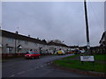
Junction of Montague Avenue and Sullivan Road
Image: © Basher Eyre
Taken: 2 Dec 2014
0.17 miles
8
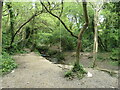
Rope swing over a stream, Shoreburs Greenway
Shoreburs Greenway links Weston Shore to Bursledon Road. It includes a wide range of different environments from formal parkland, play areas and ponds to woodland, heather and gorse scrub.
Image: © Christine Johnstone
Taken: 23 Apr 2022
0.19 miles
9
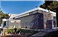
Former St Francis of Assisi, Sholing
Modern building but derelict.
Image: © Michael FORD
Taken: Unknown
0.19 miles
10
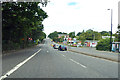
Traffic lights on A3024 Bursledon Road
The lights are for access to a retail and business park to the right.
Image: © Robin Webster
Taken: 16 Sep 2018
0.22 miles