IMAGES TAKEN NEAR TO
Carpathia Close, SOUTHAMPTON, SO18 3RP
Introduction
This page details the photographs taken nearby to Carpathia Close, SO18 3RP by members of the Geograph project.
The Geograph project started in 2005 with the aim of publishing, organising and preserving representative images for every square kilometre of Great Britain, Ireland and the Isle of Man.

There are currently over 7.5m images from over14,400 individuals and you can help contribute to the project by visiting https://www.geograph.org.uk
Image Map
Images are licensed for reuse under creativecommons.org/licenses/by-sa/2.0
Notes
- Clicking on the map will re-center to the selected point.
- The higher the marker number, the further away the image location is from the centre of the postcode.
Image Listing (4 Images Found)
Images are licensed for reuse under creativecommons.org/licenses/by-sa/2.0
Image
Details
Distance
1
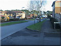
Atalantic Park View
Atalantic Park View leading to Townhill Way
Image: © Shaun Ferguson
Taken: 30 Jan 2013
0.11 miles
2
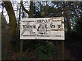
Entrance sign for former school at Townhill Park House
Townhill Park House was used as a school by Middlesex County Council until told to Southampton City Council in 1969. This sign, located at the end of River Walk, dates from that era. The house became a hostel for Merchant Navy cadets in 1971 and today is a private school with its main entrance located in Cutbush Lane, opposite Atlantic Park View.
Image: © Dave Waghorn
Taken: 16 Mar 2018
0.18 miles
4
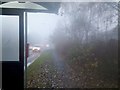
A Townhill Way bus stop in the fog
Townhill Way in Chartwell Green, taken from a foggy bus stop.
Image: © Dave Waghorn
Taken: 22 Nov 2011
0.24 miles