IMAGES TAKEN NEAR TO
Bitterne Road, SOUTHAMPTON, SO18 1DA
Introduction
This page details the photographs taken nearby to Bitterne Road, SO18 1DA by members of the Geograph project.
The Geograph project started in 2005 with the aim of publishing, organising and preserving representative images for every square kilometre of Great Britain, Ireland and the Isle of Man.

There are currently over 7.5m images from over14,400 individuals and you can help contribute to the project by visiting https://www.geograph.org.uk
Image Map
Images are licensed for reuse under creativecommons.org/licenses/by-sa/2.0
Notes
- Clicking on the map will re-center to the selected point.
- The higher the marker number, the further away the image location is from the centre of the postcode.
Image Listing (43 Images Found)
Images are licensed for reuse under creativecommons.org/licenses/by-sa/2.0
Image
Details
Distance
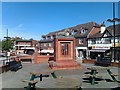
1
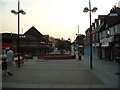
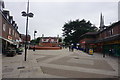
Bitterne Precinct, Southampton
Bitterne Precinct, Southampton, a popular local shopping area. This photo is looking West.
Image: © GaryReggae
Taken: 13 Jul 2005
0.02 miles
3
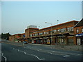
Safeway, Bitterne
A Safeway supermarket on West End Road, Bitterne.
***Now taken over by Sainsbury's***
Image: © GaryReggae
Taken: 13 Jul 2005
0.05 miles
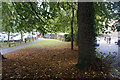
4
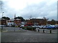
Angel Crescent car park
The church spire is in the next grid square to the south.
Image: © Shazz
Taken: 1 Mar 2013
0.05 miles
6
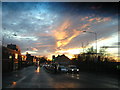
Bitterne: sunset after a day of rain
From a moving car with rain on the windscreen, so not the crispest of images, but the only chance there was to grab this light-effect as sunset faded.
Image: © Helena Hilton
Taken: 6 Jan 2007
0.06 miles
7
The former site of Bitterne School
The school has now been rebuilt on another site, and this now provides parking for Iceland and the United Reformed Church.
Image: © Bill Boaden
Taken: 29 Sep 2016
0.06 miles
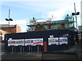
9
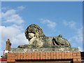
The former junction of Bitterne Road and Bursledon Road
Once a major road junction with the Red Lion as a landmark. The pub is currently closed for conversion into a Wetherspoon's, and you have to hope that they keep the original name, which dates from at least the 1860s when the present building was erected.
Image: © Bill Boaden
Taken: 29 Sep 2016
0.06 miles
10
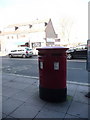
Bitterne: postbox № SO18 280 & 732, West End Road
The two slots of this postbox, outside Bitterne Post Office, have different reference numbers, perhaps indicating that there were once two separate boxes. They do have the same collection times, though - 7pm on weekdays and 12:30pm on Saturdays.
Image: © Chris Downer
Taken: 12 Feb 2011
0.07 miles