IMAGES TAKEN NEAR TO
Mansel Road East, SOUTHAMPTON, SO16 9DP
Introduction
This page details the photographs taken nearby to Mansel Road East, SO16 9DP by members of the Geograph project.
The Geograph project started in 2005 with the aim of publishing, organising and preserving representative images for every square kilometre of Great Britain, Ireland and the Isle of Man.

There are currently over 7.5m images from over14,400 individuals and you can help contribute to the project by visiting https://www.geograph.org.uk
Image Map
Images are licensed for reuse under creativecommons.org/licenses/by-sa/2.0
Notes
- Clicking on the map will re-center to the selected point.
- The higher the marker number, the further away the image location is from the centre of the postcode.
Image Listing (10 Images Found)
Images are licensed for reuse under creativecommons.org/licenses/by-sa/2.0
Image
Details
Distance
1
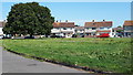
Welland Green
This area of the Millbrook Park Estate takes its names from British rivers. The houses on the far side of Welland Green are in Teme Crescent.
Image: © David Martin
Taken: 25 Aug 2019
0.06 miles
2
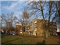
Flats on Wimpson Lane
Part of a row of 6 such 4-storey blocks along Wimpson Lane. Taken from the junction with Oakley Road.
Image: © Derek Harper
Taken: 17 Feb 2010
0.15 miles
3
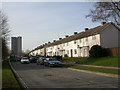
Maybush, terraced housing
On Windermere Avenue; Millbrook Tower in the distance to the left.
Image: © Mike Faherty
Taken: 2 Mar 2010
0.23 miles
4
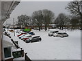
Sedbergh Road car park, Millbrook
A snowy car park in Sedbergh Road on the morning of the 2nd March 2018.
Image: © J W Parker
Taken: 2 Mar 2018
0.23 miles
5
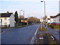
Windermere Avenue
At the junction with Borrowdale Road
Image: © Geographer
Taken: 17 Feb 2010
0.24 miles
6
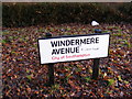
Windermere Avenue Sign
Near the junction with Borrowdale Road
Image: © Geographer
Taken: 17 Feb 2010
0.24 miles
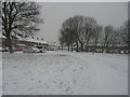
7
Sedbergh Road 1945 houses in the snow
This estate in Millbrook was built in 1945 on land from the Barker Mills family; here it is in the snow of March 2018.
Image: © J W Parker
Taken: 1 Mar 2018
0.24 miles
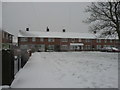
8
Sedbergh Road in the snow
Millbrook estate, houses built in 1945 weathering the snow of March 2018
Image: © J W Parker
Taken: 1 Mar 2018
0.24 miles
9
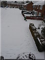
Snowy green, Sedbergh Road, Millbrook
Sedbergh Road and two of its greens under snow
Image: © J W Parker
Taken: 2 Mar 2018
0.24 miles
10
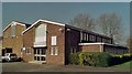
Millbrook Christian Centre
Erected in 1960.
Image: © Michael FORD
Taken: Unknown
0.25 miles