IMAGES TAKEN NEAR TO
Starboard Way, SOUTHAMPTON, SO16 8NT
Introduction
This page details the photographs taken nearby to Starboard Way, SO16 8NT by members of the Geograph project.
The Geograph project started in 2005 with the aim of publishing, organising and preserving representative images for every square kilometre of Great Britain, Ireland and the Isle of Man.

There are currently over 7.5m images from over14,400 individuals and you can help contribute to the project by visiting https://www.geograph.org.uk
Image Map
Images are licensed for reuse under creativecommons.org/licenses/by-sa/2.0
Notes
- Clicking on the map will re-center to the selected point.
- The higher the marker number, the further away the image location is from the centre of the postcode.
Image Listing (25 Images Found)
Images are licensed for reuse under creativecommons.org/licenses/by-sa/2.0
Image
Details
Distance
1
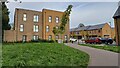
New apartment to in Starboard Way
Modern housing on the site of the former Oaklands Community School, which closed in 2008.
Image: © David Martin
Taken: 13 Oct 2024
0.05 miles
4
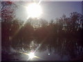
Peaceful fishing lake near Lakeside Avenue
This is one of a series of small lakes and ponds in the area, popular with fishermen, geocachers and dog walkers.
Image: © Eleanor Oakley
Taken: 8 Feb 2011
0.16 miles
5
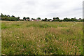
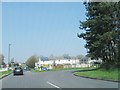
View towards Cromarty Road
Looking ESE across an area of rough grassland from the junction of Bakers Drove and Romsey Road, towards the houses on Cromarty Road.
Image: © David P Howard
Taken: 26 Jun 2014
0.17 miles
6
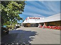
Lord's Hill, Sainsbury's
Store at Lord's Hill District Centre.
Image: © Mike Faherty
Taken: 30 Jul 2020
0.18 miles
7
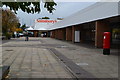
Lord's Hill District Centre
Looking past the post office towards the Sainsbury's entrance.
Image: © David Martin
Taken: 12 Oct 2018
0.19 miles
8
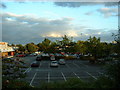
Sainsbury's car park, Lordshill, Southampton
The car park for Sainsbury's, Lordshill.
Image: © GaryReggae
Taken: 19 Jul 2005
0.19 miles
9
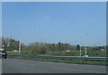
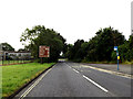
Tourist Information Roadsign on the A3057 Romsey Road
Approaching the Lordshill Roundabout
Image: © Geographer
Taken: 27 Jun 2014
0.20 miles
10
A3057 Romsey Road, Nursling
Approaching the Lordshill Roundabout
Image: © Geographer
Taken: 27 Jun 2014
0.20 miles