IMAGES TAKEN NEAR TO
Viking Close, SOUTHAMPTON, SO16 8BZ
Introduction
This page details the photographs taken nearby to Viking Close, SO16 8BZ by members of the Geograph project.
The Geograph project started in 2005 with the aim of publishing, organising and preserving representative images for every square kilometre of Great Britain, Ireland and the Isle of Man.

There are currently over 7.5m images from over14,400 individuals and you can help contribute to the project by visiting https://www.geograph.org.uk
Image Map
Images are licensed for reuse under creativecommons.org/licenses/by-sa/2.0
Notes
- Clicking on the map will re-center to the selected point.
- The higher the marker number, the further away the image location is from the centre of the postcode.
Image Listing (33 Images Found)
Images are licensed for reuse under creativecommons.org/licenses/by-sa/2.0
Image
Details
Distance
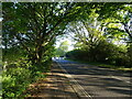
1
Roadsigns on the A3057 Romsey Road
Approaching Lordshill Roundabout
Image: © Geographer
Taken: 27 Jun 2014
0.06 miles
2
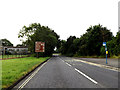
A3057 Romsey Road, Nursling
Approaching the Lordshill Roundabout
Image: © Geographer
Taken: 27 Jun 2014
0.06 miles
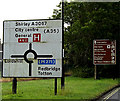
3
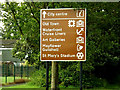
Tourist Information Roadsign on the A3057 Romsey Road
Approaching the Lordshill Roundabout
Image: © Geographer
Taken: 27 Jun 2014
0.06 miles
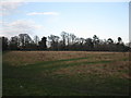
4
View towards Cromarty Road
Looking ESE across an area of rough grassland from the junction of Bakers Drove and Romsey Road, towards the houses on Cromarty Road.
Image: © David P Howard
Taken: 26 Jun 2014
0.07 miles
5
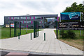
Oasis Academy Lord's Hill
A newly built academy for secondary school pupils off Romsey Road. http://www.oasisacademylordshill.org/
Image: © David P Howard
Taken: 26 Jun 2014
0.08 miles
6
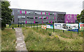
Oasis Academy Lord's Hill
A newly built academy for secondary school pupils off Romsey Road. http://www.oasisacademylordshill.org/
Image: © David P Howard
Taken: 26 Jun 2014
0.09 miles
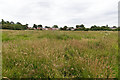
7
Bakers Drive open space
This rough ground that runs alongside Bakers Drive is well used by local people for recreation.
Image: © don cload
Taken: 17 Feb 2010
0.10 miles
8
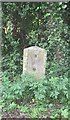
Old Milestone by the A3057, Romsey Road, Nursling
Metal plate attached (lost) to stone post by the A3057, in parish of Nursling and Rownhams (Test Valley District), Tennis Centre, Romsey Road, Nursling; opposite the Cedar School for the Physically handicapped, by the road, on East side of road. Romsey tombstone marker, erected by the Whiteparish, Romsey & Southampton turnpike trust in the 19th century.
Inscription once read:-
(Southampton)
(4)
(Romsey)
(4)
Milestone Society National ID: HA_SORO04
Image: © K Lawrence
Taken: 26 May 2003
0.10 miles
9
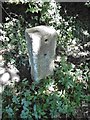
Milestone, Lord's Hill
Stone post with missing plate by the A3057, in Lord's Hill (City of Southampton). Romsey Road, 50m South of junction with Redbridge Lane, on the verge, on East side of road. Romsey tombstone marker erected by the Whiteparish, Romsey & Southampton Turnpike Trust in the 19th century.
The inscription once gave mileages to Southampton (4) and Romsey (2).
Not listed by Historic England.
Milestone Society National ID: HA_SORO04
Image: © Mike Faherty
Taken: 30 Jul 2020
0.10 miles