IMAGES TAKEN NEAR TO
Vine Road, SOUTHAMPTON, SO16 5TB
Introduction
This page details the photographs taken nearby to Vine Road, SO16 5TB by members of the Geograph project.
The Geograph project started in 2005 with the aim of publishing, organising and preserving representative images for every square kilometre of Great Britain, Ireland and the Isle of Man.

There are currently over 7.5m images from over14,400 individuals and you can help contribute to the project by visiting https://www.geograph.org.uk
Image Map
Images are licensed for reuse under creativecommons.org/licenses/by-sa/2.0
Notes
- Clicking on the map will re-center to the selected point.
- The higher the marker number, the further away the image location is from the centre of the postcode.
Image Listing (12 Images Found)
Images are licensed for reuse under creativecommons.org/licenses/by-sa/2.0
Image
Details
Distance
1
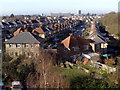
Vine Road from Princess Anne Hospital
A view across Coxford and Old Shirley from the Burley Ward, Princess Anne Hospital. The Ordnance Survey offices can be seen in the distance.
Image: © Jim Champion
Taken: 2 Mar 2009
0.06 miles
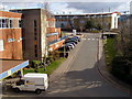
2
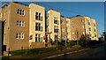
New flats being built on the corner of Vine Road
These flats are directly opposite Southampton General Hospital, which is behind the photographer.
Image: © David Martin
Taken: 15 Jul 2011
0.16 miles
3
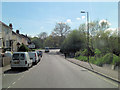
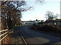
Coxford Lane descends towards Tanner's Brook
Image: © Stuart Logan
Taken: 7 May 2012
0.17 miles
4
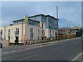
National Blood Service, Southampton
The NBS is based at the hospital site.
Image: © Alan Hawkes
Taken: 15 Apr 2009
0.18 miles
5
Apartment blocks in Coxford Road
That big round shadow is of a road sign, not the photographer's head!
Image: © David Martin
Taken: 28 Dec 2016
0.19 miles
6
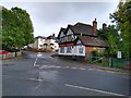
The Bridge Tavern, Coxford Road, Southampton
Considering the pub has reportedly been closed since 2007 it has survived remarkably intact. That said there was a fire there in early September 2019 which hasn't done as much damage as it might https://www.dailyecho.co.uk/news/17887294.fire-old-bridge-tavern-pub-coxford-road/
Image: © Brian Robert Marshall
Taken: 8 Oct 2019
0.20 miles
7

The Bridge Tavern
So it's not just country pubs that are closing.
Image: © Stuart Logan
Taken: 7 May 2012
0.20 miles
8
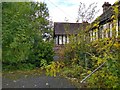
Rear aspect, The Bridge Tavern, Coxford Road, Southampton
The pub dates back to at least the 1880s http://www.closedpubs.co.uk/hampshire/southampton_bridgetavern.html but closed in 2007. There was a fire there in early September 2019 https://www.dailyecho.co.uk/news/17887294.fire-old-bridge-tavern-pub-coxford-road/
Image: © Brian Robert Marshall
Taken: 8 Oct 2019
0.20 miles
9
Aldermoor Road, Southampton
Towards the Eastern end of Aldermoor Road, looking East. This part of Southampton is interspersed by numerous green spaces separating the various estates of 20th century housing.
Image: © GaryReggae
Taken: 29 Jan 2006
0.21 miles
10
View from Princess Anne Hospital
View from a window in Burley Ward, Princess Anne Hospital. The main entrance can be seen bottom left. The access road leads up to Coxford Road, with the rest of the General Hospital on the far side of the road. This photo was taken whilst awaiting the birth of my son, born in one of the Princess Anne theatres early the next morning.
Image: © Jim Champion
Taken: 22 Feb 2009
0.22 miles