IMAGES TAKEN NEAR TO
Wonston Road, SOUTHAMPTON, SO16 5JL
Introduction
This page details the photographs taken nearby to Wonston Road, SO16 5JL by members of the Geograph project.
The Geograph project started in 2005 with the aim of publishing, organising and preserving representative images for every square kilometre of Great Britain, Ireland and the Isle of Man.

There are currently over 7.5m images from over14,400 individuals and you can help contribute to the project by visiting https://www.geograph.org.uk
Image Map
Images are licensed for reuse under creativecommons.org/licenses/by-sa/2.0
Notes
- Clicking on the map will re-center to the selected point.
- The higher the marker number, the further away the image location is from the centre of the postcode.
Image Listing (106 Images Found)
Images are licensed for reuse under creativecommons.org/licenses/by-sa/2.0
Image
Details
Distance
1
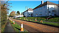
Springford Road closed for resurfacing
Image: © David Martin
Taken: 18 Nov 2019
0.06 miles
2
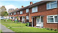
Houses in Springford Road
These house designs are typical of Southampton's 1950s local authority-built housing.
Image: © David Martin
Taken: 8 Apr 2019
0.06 miles
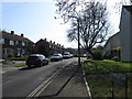
5
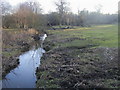
Tanner's Brook
Tanner's Brook by Aldermoor Bridge
Image: © Shaun Ferguson
Taken: 30 Jan 2010
0.14 miles
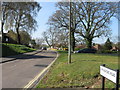
6
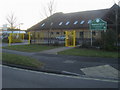
Rosewood School
Rosewood School on Aldermoor Road
Image: © Shaun Ferguson
Taken: 30 Jan 2010
0.14 miles